Tsunami Warning System: Preparing for the unpredictable

UNESCO is the UN Agency in charge of ocean science. With its Intergovernmental Oceanographic Commission joined by 150 Member States, and its expertise in the culture and education fields, UNESCO coordinates actions by governments, scientists, the private sector, civil society and other UN organizations. Together, we created the tsunami warning system. We map the ocean depths, identify species, work to ensure that ocean literacy is included in school curricula and protect ocean sites, which are home to critical biodiversity and incomparable beauty. In this story, we tell you more about UNESCO’s work on the tsunami early warning system, how it works and how it saves lives.
Tsunamis are rare events. But when nature’s fury is unleashed, their deadly effects are devastating. The initial impact may make the front page of news media, but the aftermath on communities, livelihoods and the environment will linger for many years after the natural disaster strikes.
In the last century, 58 of them have claimed more than 260,000 lives, surpassing any other natural hazard. More are expected in the future as the sea-level rises due to climate change.
Therefore, preparing for the unpredictable can mean the difference between surviving and not.

11 March, 14:00 UTC: the Earth shakes

An earthquake occurs in the Atlantic, 100 kilometres east of the Lesser Antilles – the long, delicate arc of small Caribbean islands fanning out between the Caribbean Sea and the open ocean. The volcanic archipelago, home to 3.2 million people, is perched on one of the tectonic plates that sit on the Earth’s crust.
Just as the plate slips along the Caribbean fault line, a massive burst of energy akin to a nuclear warhead explosion sets off a giant shockwave 25 kilometres beneath the planet’s surface.
Strong earthquakes are highly destructive in their own right. But they can also trigger other cataclysmic natural hazards.
As the seabed suddenly rises, it displaces colossal volumes of water, producing powerful waves that spread outward in all directions, just like the ripples from a stone thrown into a pond.
The smaller, ocean-facing Antilles are on the frontline of the looming wave. The larger islands – Cuba, Haiti, Jamaica and Puerto Rico – as well as the communities in the Gulf of Mexico and coastal Venezuela, are also under threat. Nearly 160 million people are in imminent danger.
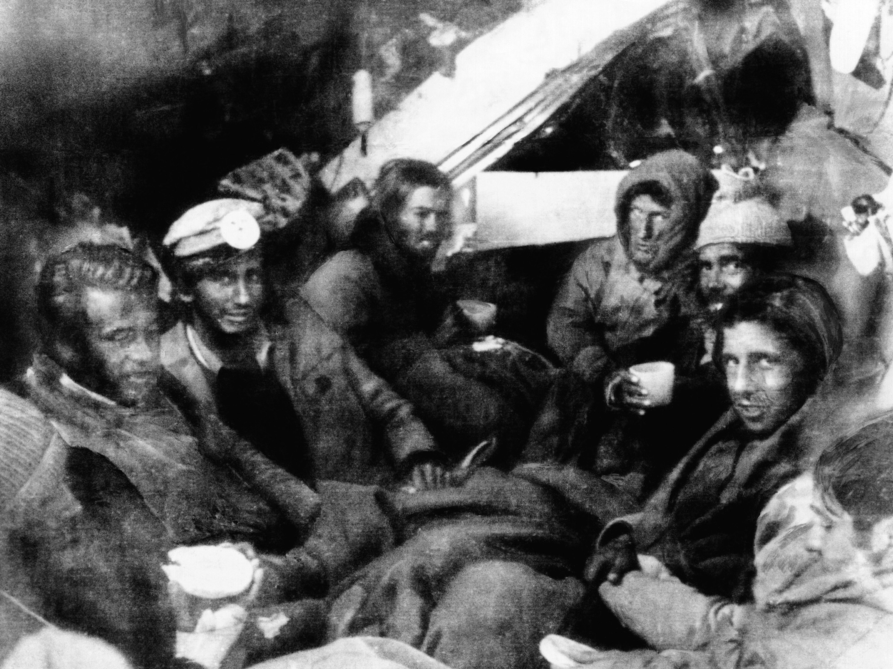
Tsunami Waves : digitally-scanned photos from the ITIC collection

11 March, 14:02 UTC: the earthquake is detected, tsunami sensors activate

The monitoring station in Martinique picks up the tremor and estimates it at 8.5 on the Richter scale. The large magnitude is cause for concern. Major earthquakes that occur beneath the sea lead to deadly tsunamis. Still, visual detection in the vast open ocean remains challenging because the powerful tsunami waves are low in height while they travel across deep water.
That is why shore-based tide gauges and deep-ocean buoys continuously monitor the oceans to detect any threatening changes. These silent sentinels can spy and track any minuscule change in the temperature of the seafloor and its pressure.
An ocean buoy anchored in the depths of Barbuda – a flat coral island hugged by white-and-pink sand beaches and crystal-clear waters – senses the force of the hidden submarine wave and alerts the monitoring centre on the sister island of Antigua.

11 March, 14:05 UTC: the Tsunami Warning System raises the alarm
Antigua feeds the data on the force of the approaching wave into the Tsunami Warning System, which alerts all observatories in the region. Authorities in all neighbouring countries are immediately alerted: the rapid transmission of information to dedicated centres is vital to lessen the damage caused by tsunamis.
Disaster prediction and prevention Preventing large-scale disasters calls for a high degree of international and multilateral cooperation. After the 1960 Chilean tsunami, which left a trail of death and damage as far away as Japan, UNESCO’s Intergovernmental Oceanographic Commission (IOC-UNESCO) stepped in to set up the Pacific Ocean Tsunami Warning System, the first of its kind.
The 9.5 magnitude earthquake in Chile, the largest recorded in the 20th century, set off a tsunami that battered the South American coastline for over 4,000 kilometres with waves up to 25 metres high.
Fifteen hours later, the tsunami, which by then had travelled 10,000 kilometres, struck Hawaii, then Japan and the Philippines. The final death toll was over 2,000.
The scale of the disaster highlighted the need for a warning alert system in the Pacific, where most of the world’s deadliest tsunamis occur. Over the years, the alert system has evolved beyond issuing warnings. UNESCO’s role now includes prevention, preparing communities to respond to tsunami threats and fostering the latest tracking and detection technologies.
Other exposed regions, the Indian Ocean, the Caribbean, the Northeast Atlantic and the Mediterranean, have also adopted Early Tsunami Warning Systems based on the Pacific model.
11 March, 14:15 UTC: public alerts go out

The tidal wave is already in sight of the Lesser Antilles. There is little time left before it hits the coast. Tsunami waves in the deep ocean can travel thousands of kilometres, up to 800 kilometres per hour, the speed of a jet aircraft.
In Martinique, the local government alerts the municipalities and the media, which immediately publish alerts. Police sirens and loudspeakers give evacuation orders. Guided by their teachers, schoolchildren rush out of their classrooms, heading for higher ground. Office workers and tourists seek safety on the rooftops of high-rise buildings.
Empowering communities to react An early warning system can be effective only when the population is well aware of the tsunami phenomenon and knows what to do in case of an emergency.
This is vital when tsunamis are generated close to the coast and there may not be time for official evacuation orders.
As part of IOC-UNESCO coordination plans, communities are empowered to play an active role through self-evacuation if a strong earthquake is felt or a strong roaring sound – similar to a train or a jet aircraft – is heard. Highly visible and labelled evacuation routes help show the best access to nearby higher grounds or the higher floors of tsunami-proof buildings.
11 March, 14:16 UTC: the sea level drops

As the tsunami approaches the coast, the sea is drawn back due to the vacuum effect caused by the wave. The water along the shoreline of Anguilla, the most northerly of the Leeward Islands in the Lesser Antilles, is dragged back dramatically, exposing the shallow coral reef and stranding many marine creatures.
The expanding shoreline is nature’s warning that a tsunami is approaching. It is a sign that there are only seconds or, at best few minutes, before the full impact of the first wave.
When the sea disappears Survivors of the 2004 Indian Ocean tsunami said the water had receded for up to 2.5 kilometres along the coastlines of Indonesia and Thailand. Bystanders, many of them children, lingered on the exposed beach to observe the phenomenon and collect stranded fish.
The lack of tsunami awareness, combined with the absence of a coordinated alert system, contributed to the high death toll. There were an estimated 227,000 fatalities in 14 countries, with India, Indonesia, Sri Lanka and Thailand being the hardest-hit.
Still, some coastal communities in Indonesia were able to evacuate despite the lack of alarms, thanks to local traditions and folklore developed during previous tsunami disasters.
The tragedy highlighted the importance of understanding the early signals of an approaching tsunami.
For example, the "disappearing sea" may not happen at all. Sometimes the sea suddenly swells without any warning signs, surprising people and giving them little time to flee.
Tsunamis can be detected using the human senses
Tsunami evacuation signs.

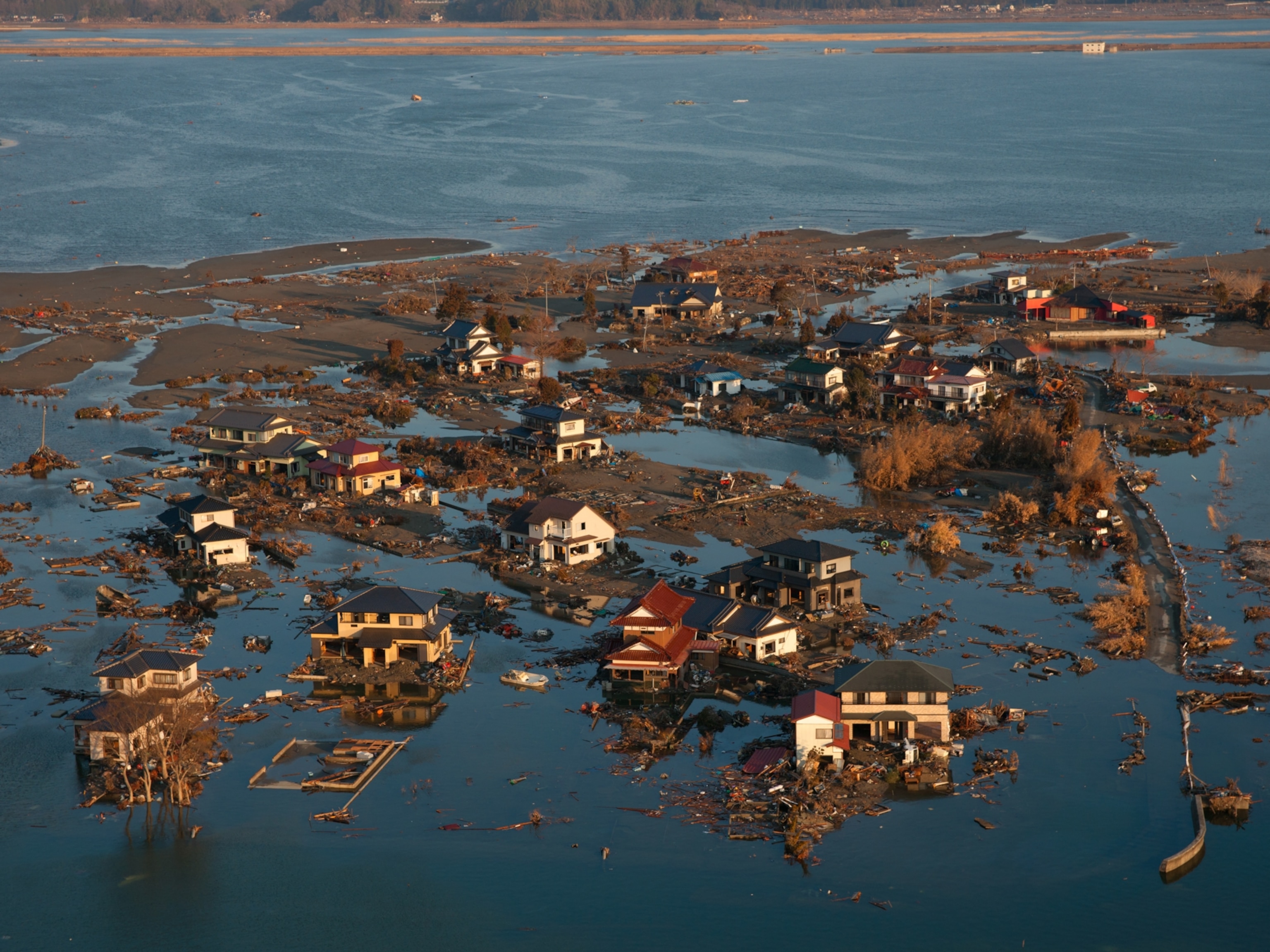
11 March, 14:20 UTC: the first wave hits

When the swell approaches the shore, the leading edge of the wave begins to slow down in shallow waters. As the tsunami loses its speed nearing the coast, the first wave suddenly swells as much as 20 metres in height. The massive wall of water rushes towards the coastline, demolishing everything in its way. The force of the wave is powerful enough to overturn boats, crumble palm trees and sweep away beach shacks.
Why is it called tsunami ? The flatter the coast, the stronger is the impact from the waves. This is the reason why the effects of the tsunamis are more devastating in ports, beaches and in the mouths of the rivers. It also explains the origin of the word. In Japanese, tsunami means bay or harbour wave.
11 March, 14:40 UTC: the second wave hits

Tsunamis always surge in multiple waves. The first wave may not be the largest, and often it is the second or later waves that are the biggest.
The second wave, towering at 30 metres, hits after as little as five minutes. The coastal areas are completely devastated and under water.
We heard a second wave, and another. There were no houses anymore.
A tsunami survivor
In 1950, Markus Kailhulu was a 12-year-old living in the village of Hutumuri in Indonesia, when a tsunami hit the Moluccas. The villagers had evacuated to higher ground and witnessed the destruction brought by the waves.

We went to see and it looked like a flood from up there. We heard a second wave, and another. There were no houses anymore, all gone,’ he says. ‘The waves swept it all. It hit the edge of the mountain, it went back while taking the houses. The church was the only building left.
11 March, 15:00 UTC: other waves hit

The first two waves were massive walls of water. The others now resemble a surging tide that inundates coastal areas, carrying debris from the destruction caused by previous waves.
Entire neighbourhoods have been washed away. Up on the hills, people stare at the devastation below with fear and incomprehension.
World Tsunami Awareness Day People experiencing a tsunami should be aware that the danger may not have passed and should await official confirmation that it is safe to return. Raising awareness and education among the coastal communities is essential to prepare citizens on how to respond to the risk of tsunamis and cope with their aftermath. The UN-supported World Tsunami Awareness Day is the brainchild of Japan, which due to its repeated experience with tsunamis, has built up over the years major expertise in early warnings and public awareness to reduce future impacts. The event, held every year on 5 November, calls on countries, international bodies and civil society to raise tsunami awareness and share innovative approaches to reduce the death toll and devastation. Posters, flyers, e-learning courses and guidelines as well as games teach children, who are among the most vulnerable groups, how to identify and cope with a tsunami.
World Tsunami Awareness Day
"The game is fun and worth a try." Tsunami Ready board game, World Tsunami Awareness Day 2021, Indian Ocean.

Playing the Tsunami Ready game
The Indian Ocean Tsunami Information Centre has developed a Tsunami Ready board game for children living in the coastal communities. "Playing the game, I’m able to learn a lot, such as what are the mitigation efforts that we can do at community, family as well as individual levels," says Sasa Tsairoo, a young game player who took part in the World Tsunami Awareness Day in 2021. "The game is fun and worth a try."
11 March, 19:43: rescue and recovery begins

Local authorities issue an "all clear" that it’s safe to return to the coastal areas. People rush out into the streets, stunned. In the midst of flooding and devastation, search and rescue teams are busy across the archipelago in a desperate attempt to find survivors. Essential utilities like water, telecommunications, gas lines and electricity are inoperable. The coastline is devastated with flooding, damaged buildings, debris, fires and hazardous spills. Many are missing. Many more have lost their homes and may have to stay in shelters or public buildings until the reconstruction begins.
Reality or fiction? This report is, in fact, the fictional scenario of a tsunami in the Caribbean, based on a drill exercise.
Caribe Wave is an annual tsunami preparedness exercise set up by the United Nations and overseen by IOC-UNESCO. The date and time of the simulation are not a random choice: it is the anniversary of the Japan earthquake and tsunami that killed nearly 16,000 people on 11 March 2011.
Under IOC-UNESCO’s oversight, the drills allow different countries and territories, emergency management agencies and communities at risk to test, validate and update their tsunami response plans.
The exercise, which in 2019 involved up to 800,000 people to simulate a catastrophic scenario, focuses on the coordination among countries, improving response procedures and training the local population to become prepared.
It also plays a crucial role in fostering resilient communities. Tsunamis are a real threat in the Caribbean. At least 75 have hit the region over the past 500 years. Some countries facing the Gulf of Mexico are also exposed to the double threat of tsunamis along their Pacific coastlines.
Thanks to Caribe Wave, over 50 coastal communities are now considered Tsunami Ready. This means that these communities now have the tools to face not just tsunamis, but also other coastal hazards.
Tsunami Ready recognition As of 2021, six countries have piloted UNESCO’s Tsunami Ready Programme, while seven more are in progress. The programme aims to build resilient communities through awareness and preparedness strategies that will protect life, livelihoods and property from future tsunamis.
One of the achievements in becoming Tsunami Ready for us in Saint Kitts and Nevis was the ability to enhance our disaster preparedness. That was very vital and critical in also encompassing coastal hazards
"The ability to enhance our disaster preparedness" – World Tsunami Awareness Day 2021, Saint Kitts and Nevis

Preparing for future tsunamis
Millions of people live in coastal areas across the world where the rising sea level is increasing the risk of tsunamis.
In 2021, the United Nations set the goal of making all at-risk communities Tsunami Ready by 2030. IOC-UNESCO Tsunami Ready recognition has shown how different countries and communities can work together to reduce the risk of catastrophic coastal hazards that can cause death and destruction, hitting the livelihoods of vulnerable populations.
By improving warnings, enhancing preparedness and practicing response drills, these communities can prepare and become resilient, together.
"The Tsunami Ready programme reduces the risk for our communities." World Tsunami Awareness Day 2021

Related items
- Warning systems
Based on Zip Code Change
- Shop the Red Cross Store
Tsunami Preparedness
- Share via Email
- Share on Facebook
- Share on Twitter
- Share on LinkedIn
Need Help Now?
If you are in immediate need of help, please contact your local Red Cross » or find an open shelter » .
A tsunami is a series of ocean waves caused by earthquakes, landslides, or volcanic eruptions. These waves can kill and injure people and destroy entire communities. Tsunamis strike as fast moving walls of water that flood, drain, and re flood the land for hours. Tsunamis can flood more than a mile inland. But we can take action to prepare. Prepare now to protect yourself and your loved ones.
What Should You Do Before a Tsunami
Know your risk .
- Tsunamis can strike any U.S. coast, but the risk is greatest for communities with Pacific and Caribbean coastlines. Coastal areas such as beaches, bays, lagoons, harbors and river mouths and areas along rivers and streams that lead to the ocean are the most vulnerable.
- If you live on or near a coast, find out if you are in a tsunami hazard zone.
Make Plans to Stay Safe
- Learn about your community’s tsunami evacuation plan. Some communities have maps with evacuation zones and routes. Know and practice these routes in the places where you spend time.
- If your community does not have a tsunami evacuation plan, identify a safe place at least 100 feet (30 meters) above sea level or at least 1 mile (1.6 km) inland.
- Be ready to move quickly to higher ground or inland. Don’t wait for an official alert.
- If you are near the coast, a tsunami could follow an earthquake. As soon as the shaking stops, move quickly to higher ground or inland away from the coast. Don’t wait for an official alert.
Understand Tsunami Alerts and Natural Signs of a Tsunami
- There are two ways that you may be warned: an official tsunami alert or a natural sign of a tsunami. Both are equally important. You may not get both.
- A natural sign of a tsunami may be your first, best, or only warning that a tsunami is on its way. Natural signs include an earthquake, a loud roar from the ocean, or unusual ocean behavior, such as a sudden rise or wall of water or a sudden retreat of the water, showing the ocean floor. If you experience any of these signs, a tsunami could be coming. Immediately move to higher ground or inland away from the coast. Don’t wait for an official alert.
- Tsunami alerts are shared on local radio, television, weather radios, and other emergency alert systems. Understand the different alerts and what to do when you receive them.
Download the Tsunami Safety Checklist
Checklist Available in English and Spanish
- Tsunami Safety Checklist - English
- Tsunami Safety Checklist - Spanish
Get Preparation Tips for the Whole Family

What Should You Do During a Tsunami
Move to high ground or inland.
If your community is under a Tsunami Warning or you see natural signs of a tsunami:
- DANGER-TAKE IMMEDIATE ACTION! MOVE TO HIGH GROUND OR INLAND (AWAY FROM THE WATER).
- If you are near the coast and experience shaking from an earthquake: DROP , COVER , and HOLD ON to protect yourself. As soon as the shaking stops, MOVE TO HIGH GROUND OR INLAND (AWAY FROM THE WATER).
- Once you have evacuated, stay there until officials say it is safe to return home or direct you to evacuate further inland.
What Should You Do After a Tsunami
Stay safe .
- Understand the dangers you may face after a tsunami. Many injuries happen during cleanup.
- If you have evacuated, listen to local officials to learn if it is safe to return home. If there is a lot of damage, it may be days before it is safe to return to your community.
- Avoid roads that were flooded, they may be damaged and could collapse.
- Do not touch floodwaters. They may contain sewage, bacteria, and chemicals that can make you sick.
- Avoid damaged or fallen power lines. Assume all wires are live and dangerous.
- When officials allow, inspect the outside of your home for damage before reentering.
- If your home is damaged, it may be safer to wait for a professional.
- Be aware of carbon monoxide poisoning. Do not use gasoline, propane, natural gas or charcoal-burning devices inside a home, basement, garage, tent, or camper — or even outside near an open window. Carbon monoxide can’t be seen or smelled, but it can kill you fast. If you start to feel sick, dizzy or weak, get to fresh air right away — do not delay.
- Avoid using candles because of the fire risk. Use battery- powered lights and flashlights instead.
Stay Healthy
- Monitor your local health department for information about drinking water safety. Tsunamis can contaminate water supplies.
- When in doubt, throw it out. Throw away food that got wet or warm.
- Clean and disinfect everything that got wet. Mud left from floodwaters can contain sewage, bacteria, and chemicals. Mold can become a problem if a building is flooded and not completely dried out within 24-48 hours. Mold exposure can lead to asthma attacks, eye and skin irritation, and allergic reactions.
Clean Up Safely
- Follow all specific recommendations from your local public health officials. Use the right safety gear including gloves, goggles, rubber boots, and N95 masks. Know how to safely operate any needed equipment.
- Pace yourself. Cleaning up is a big job. Rest when you need to. Work with other people and get help lifting heavy objects. Decide which cleanup tasks are most important and focus on those first.
- Avoid heat-related illness. If you are without air conditioning in hot weather, be aware of risk for heat stroke, heat exhaustion, heat cramps, and fainting.
Take Care of Yourself
- It’s normal to have a lot of bad feelings, stress, or anxiety after a disaster or other emergency.
- Eat healthy food and get enough sleep to help you deal with stress.
- You can contact the Disaster Distress Helpline for free if you need to talk to someone. Call or text 1-800-985-5990
Explore Related Safety Topics

Free App to Help Your Family Stay Safe

Find our Emergency App in the Apple Store » or Google Play »
Aplicación de Emergencias - ahora disponible en español » también!
Help people affected by disasters big and small.

A U.S. Marine helicopter loaded with food flies over Lampuuk in northern Sumatra after a tsunami killed most of the village's 7,000 residents–and nearly 230,000 people on coastlines around the Indian Ocean.
Tsunami safety tips
These massive waves involve intense force and overwhelming volumes of water. Here's how to prepare.
With the ability to approach shores at 30 miles an hour and rise more than 100 feet high, tsunamis pose a deadly threat to coastal populations. The 2004 Indian Ocean tsunami and the 2011 Tohoku tsunami are two vivid and tragic examples of these waves' destructive power.
The most important step in staying safe during a tsunami—or any natural disaster, for that matter—is to know how vulnerable your area is in the first place. Many local governments map hazard areas and evacuation routes for communities at risk, while the U.S. National Weather Service offers a nationwide map with links to resources .
"Know what your risks are," says Kevin J. Richards, a natural hazards officer for the Hawaii Emergency Management Agency. "What's likely going to impact your home or your area?"
How to prepare
● Know the warning signs of a tsunami: rapidly rising or falling coastal waters, a loud roar from the ocean, or rumblings of an earthquake . “If people along the Indian Ocean coastline on December 26, 2004, were aware of and heeded these natural warnings, fewer people would have died,” says Rocky Lopes, administrator of the National Tsunami Hazard Mitigation Program . He adds, “A strong myth is that tsunamis always cause the ocean to recede before [the powerful] waves flood in. In some areas, particularly on islands, water recession may not happen.”
● Familiarize yourself with your government's warning system and subscribe to alerts. In the U.S., NOAA Weather Radio is a good resource.
● Map your evacuation route—not just for your home, but work, school or caregivers , or any place else where your family tends to be. Know how to get to safety on foot—roads may not always be feasible.
● Have your evacuation plan ready and rehearsed now. That way, Richards says, "You don't have to think about it. You just go and do it."
● Keep an emergency kit or "go bag" handy at home or in your car. The American Red Cross offers tips for stocking it here , including food, water, and a cell phone with chargers.

● Coordinate with loved ones on reuniting. "What happens when the family has to respond from separate areas?" Richards recommends asking. "How do you eventually come back together?"
During a tsunami
● If you're in a tsunami area and there is an earthquake, first drop to the floor, cover your head and neck, and hold on to something stable. If you're in a low-lying area, move inland as soon as possible.
● Listen for official warnings, but also listen and watch for natural signs. "Listen to the authorities, but do not wait for tsunami warnings and evacuation orders," counsels the U.S. site Ready.gov .
● People often mistake the distance they have to go to be safe. "Many people think they've got to go miles," Richards says, "when it might be just right behind Johnny's house." If you're a visitor staying in a tall concrete hotel, he adds, going above the fourth floor likely will be safer than evacuating.
● Stay put in a safe area until an official all-clear is given. The first wave of a tsunami may not be the last or the strongest and the danger can last for hours or even days, according to the National Weather Service .
After a tsunami
● Stay clear of damaged or flooded areas and downed power lines.
● Listen for further alerts and instructions about evacuation zones and shelters.
● Use texts and social media to communicate with loved ones, as phone systems are likely to be down or busy. The American Red Cross has a registry where you can list yourself as safe and well .
Follow these common-sense guidelines from the U.S. Centers for Disease Control and Prevention on food and water safety, including using bottled, boiled, or treated water and throwing away perishable foods left unrefrigerated for more than four hours.
LIMITED TIME OFFER
Receive up to 2 bonus issues, with any paid gift subscription!
Related Topics
- EARTHQUAKES
You May Also Like
Japan's 2011 megaquake left a scar at the bottom of the sea. Scientists finally explored it.
Source of mysterious global tsunami found near Antarctica
Cape Cod may have the highest density of great white sharks in the world
What causes earthquakes?
‘Society of the Snow’ is based on a true story. Here’s what really happened.
- History & Culture
- Photography
- Environment
- Paid Content
History & Culture
- Mind, Body, Wonder
- Terms of Use
- Privacy Policy
- Your US State Privacy Rights
- Children's Online Privacy Policy
- Interest-Based Ads
- About Nielsen Measurement
- Do Not Sell or Share My Personal Information
- Nat Geo Home
- Attend a Live Event
- Book a Trip
- Inspire Your Kids
- Shop Nat Geo
- Visit the D.C. Museum
- Learn About Our Impact
- Support Our Mission
- Advertise With Us
- Customer Service
- Renew Subscription
- Manage Your Subscription
- Work at Nat Geo
- Sign Up for Our Newsletters
- Contribute to Protect the Planet
Copyright © 1996-2015 National Geographic Society Copyright © 2015-2024 National Geographic Partners, LLC. All rights reserved

Tsunami Warning and Preparedness: An Assessment of the U.S. Tsunami Program and the Nation's Preparedness Efforts (2011)
Chapter: summary.
A tsunami is a series of waves that can move on shore rapidly, but last for several hours and flood coastal communities with little warning. Tsunamis can be triggered by a variety of geological processes such as earthquakes, landslides, volcanic eruptions, or meteorite impacts. Since modern record keeping began in 1800, they have taken many lives in Hawaii, Alaska, Puerto Rico, the Virgin Islands, California, Oregon, and American Samoa. The threat of a potentially catastrophic tsunami on U.S. soil looms in seismically active regions in the Pacific and Atlantic ( Figure S.1 ). More recently, tsunamis generated by earthquakes in West Java (July 2006), Samoa (September 2009), and Chile (February 2010) have flooded some U.S. coastlines, highlighting the need for a focused and well-coordinated effort to minimize the loss of life and property.
In the wake of the catastrophic 2004 Indian Ocean tsunami, which caused more than 200,000 deaths and widespread destruction, Congress passed two laws intended to increase efforts to diminish the potential impact of a tsunami. The first P.L. 109-13 in 2005 was aimed at expanding the current tsunami detection system; and the second P.L. 109-424 in 2006 asked the National Oceanic and Atmospheric Administration (NOAA) and the National Tsunami Hazard Mitigation Program (NTHMP) to strengthen the nation’s tsunami detection, warning, education, and preparedness efforts.
At the same time, Congress charged the National Academy of Sciences (NAS) to review the nation’s progress toward the ability to detect and forecast tsunamis. In particular, the committee was asked to review how the expansion of the sea level sensor network has improved the ability to detect and forecast tsunamis; how the tsunami program could be improved; and how well it is coordinated with other efforts. The NAS expanded the scope of the study to also review the nation’s ability to minimize the impact from future tsunamis by educating and preparing the American public. The complete statement of task is provided in Appendix B .
Overall, the committee found that the nation’s tsunami efforts have improved in several ways since 2004. For example, the expansion of the Deep-ocean Assessment and Reporting of Tsunamis (DART) sensor network has improved the ability to detect and forecast the size of tsunamis, the number and quality of hazard and evacuation maps has increased, and several states have assessed the number and types of vulnerable individuals in tsunami-prone areas. In addition, numerous tsunami education and awareness efforts have been initiated.
However, current capabilities are still not sufficient to meet the challenge posed by a tsunami generated close to land (see Box S.1 ). Near-field tsunamis can reach the coast just minutes after the triggering event—leaving little time to disseminate official warning messages. Tsunami education and preparation is necessary to ensure people are aware of the tsunami risk in their community and know how to recognize natural cues, such as the tremors of a tsunami-triggering earthquake, even if they do not receive an official warning. Communities at a

FIGURE S.1 Global map of active volcanoes and plate tectonics illustrating the “Ring of Fire” and depicting subduction zones; both areas associated with frequent seismic activity. SOURCE: http://vulcan.wr.usgs.gov/Imgs/Gif/PlateTectonics/Maps/map_plate_tectonics_world_bw.gif ; USGS.
greater distance from the triggering event might feel the ground shaking only weakly and not recognize the need to evacuate although a tsunami could arrive in as little as an hour. In this case, detection, forecast, and warning systems would need to operate efficiently, and decision makers at Tsunami Warning Centers and state and local emergency managers would need to coordinate closely to ensure that a clear, consistent message is delivered— a daunting challenge that will require major improvements in all parts of the end-to-end tsunami program.
Considering the many independent and disparate efforts currently ongoing as part of the nation’s tsunami hazard mitigation efforts, the committee concluded that the best way to improve the current end-to-end tsunami warning system would be to define the characteristics of an ideal system that detects and forecasts the threat and coordinates risk assessment, public education, and the response to minimize loss of life and property in the event of a tsunami. Each component (risk assessment, education, detection and forecasting, and warning management) of this idealized system could then be compared against current and planned efforts to identify areas that need improvement.
LAYING THE FOUNDATION: A COMPREHENSIVE NATIONAL ASSESSMENT OF TSUNAMI RISK
Understanding the nation’s tsunami risk 1 is the first step to building a comprehensive tsunami preparedness program. The nation is just beginning to define the hazards tsunamis pose, the populations and societal assets they threaten, and the readiness of individuals and communities to evacuate. Although much progress has been made, the nation remains far from understanding enough of its tsunami risk to set risk-based priorities for state and national efforts in tsunami preparedness, education, detection, and warning.
Assessing tsunami risk is challenging: there is a paucity of information about the frequency, source, and characteristics of past tsunamis and their reoccurrence intervals; vulnerability of coastal communities cannot be assessed without considering interdependencies from a larger economic and sociopolitical context; and the potential impacts of future events are uncertain. Although difficult to assess, societal risk from tsunamis is critical information in the development and prioritization of risk-reduction efforts including: education, preparedness planning, warning-system development, mitigation, and response strategies at the local, state, and federal level. The level of sophistication, accuracy, resolution, and format required for assessing societal risk to tsunamis will depend on the intended use of the information.
Recommendation: NOAA and its NTHMP partners, in collaboration with researchers in social and physical sciences, should complete an initial national assessment of tsunami risk in the near term to guide prioritization of program elements.
Tsunami hazard assessments focus on the physical characteristics of future tsunamis, especially on those that can pose a threat to people and the things they value. These characteristics
include the speed of onset, impact forces, currents, and the area that will be flooded. Understanding the hazard also requires an understanding of tsunami sources, for example, how often a coast is likely to have a tsunami and how large of a tsunami a source might generate. A typical tsunami hazard assessment accordingly includes:
studies of the locations, sizes, and histories of tsunami sources, which are usually earthquakes but can also be landslides or volcanic eruptions;
inundation models, which determine the areas most likely to be flooded;
hazard maps, which portray inundation models on maps that show roads, elevation and buildings, and other critical infrastructure; and
evacuation maps, which depict areas that need to be evacuated in the event of a tsunami and show evacuation routes to safe havens.
Modeling tsunami inundation begins at the tsunami source with estimates of the seafloor deformation that initiates the tsunami. The simulation also requires accurate information on the topography of the seafloor to understand the surface over which tsunami waves propagate, and a robust computational model to simulate the formation of tsunami waves.
Knowledge of the sizes and recurrence intervals of tsunami-triggering events is only now emerging and is improving the understanding of tsunami sources critical to producing a comprehensive tsunami hazard assessment; but currently, no formal procedures for periodic re-evaluation of tsunami risks exist. The U.S. Geological Survey’s (USGS) National Earthquake Hazards Reduction program serves as an example of a successful and useful approach to periodic national hazard assessments that NOAA and its NTHMP partners could adapt. In particular, the USGS updates the U.S. National Seismic Hazard Maps at six-year intervals nationwide and at other intervals regionally.
Recommendation: NOAA and its NTHMP partners should institute a periodic assessment of the sources of tsunamis that threaten the United States.
The committee concludes that the accuracy and realism of tsunami inundation models is limited by scientific uncertainties in determining the source of tsunamis, limited spatial resolution of bathymetry, a lack of topography data, and difficulties in modeling the complexity of processes that take place when the tsunami wave interacts with buildings and natural features of the coast. Modeling efforts would greatly benefit from a rigorous vetting process, peer-review, and validation with field data.
Recommendation: To improve tsunami inundation modeling, the NTHMP should periodically review progress in hydrodynamic modeling.
Moreover, the committee found that the development and use of inundation models is not occurring in a coordinated or standardized fashion across the NTHMP. Instead, each member state independently selects the tsunami source, bathymetric and topographic data, and numerical code. Although state resources are used to leverage federal resources, this state-by-state based approach to tsunami inundation mapping, coupled with inadequate coordination
and consensus among NTHMP modelers and no external peer review, has created significant disparities in the methods, criteria, and judgments employed in tsunami inundation modeling and the resulting hazard maps that are based on these models.
Recommendation: The NTHMP should reduce unnecessary and costly disparities in inundation modeling approaches among states and territories. The NTHMP should conduct modeling efforts consistently across political boundaries and execute efforts through a cooperative partnership among NOAA, the USGS, and NTHMP members.
Evacuation maps are critical tools for preparing and educating the public about the hazard and the appropriate response before an impending tsunami. For most at-risk communities, the committee concludes that progress has been made toward generating improved evacuation maps. However, methods to produce evacuation maps vary greatly among NTHMP member states; that means at-risk populations must try to interpret different representations of tsunami risk. Due to the absence of uniform quality standards, evaluative metrics, or guidelines on effective approaches, the committee found it difficult to assess whether current evacuation maps are sufficient for enabling effective evacuations or preparing the public.
Recommendation: The NTHMP Mapping and Modeling Subcommittee should develop guidelines on evacuation-map production that fosters consistency in format and quality across the United States, and a national, online repository for tsunami evacuation maps.
Tsunamis pose risks only if they have the potential to impact people or the things people value. Therefore, a first step in understanding vulnerability is to inventory the number and characteristics of individuals in tsunami hazard zones. In addition, emergency managers should assess their demographic characteristics, as these can affect an individual’s ability to receive, understand, and respond to warning messages. For example, the very young and very old may need evacuation assistance and thus have higher sensitivity to tsunami hazards. Currently, there is no national assessment of population exposure and sensitivity to tsunamis, including the number and types of individuals in tsunami hazard zones. This lack of information limits abilities to assess national tsunami risk, develop realistic evacuation plans, and tailor education efforts to at-risk individuals.
Recommendation: The NTHMP should periodically inventory the number and type of people in tsunami hazard zones, with special attention to groups whose heightened sensitivity to tsunamis could constrain their ability to prepare for and evacuate from future tsunamis. The NTHMP should provide guidelines on how to use this information to tailor evacuation planning and education efforts.
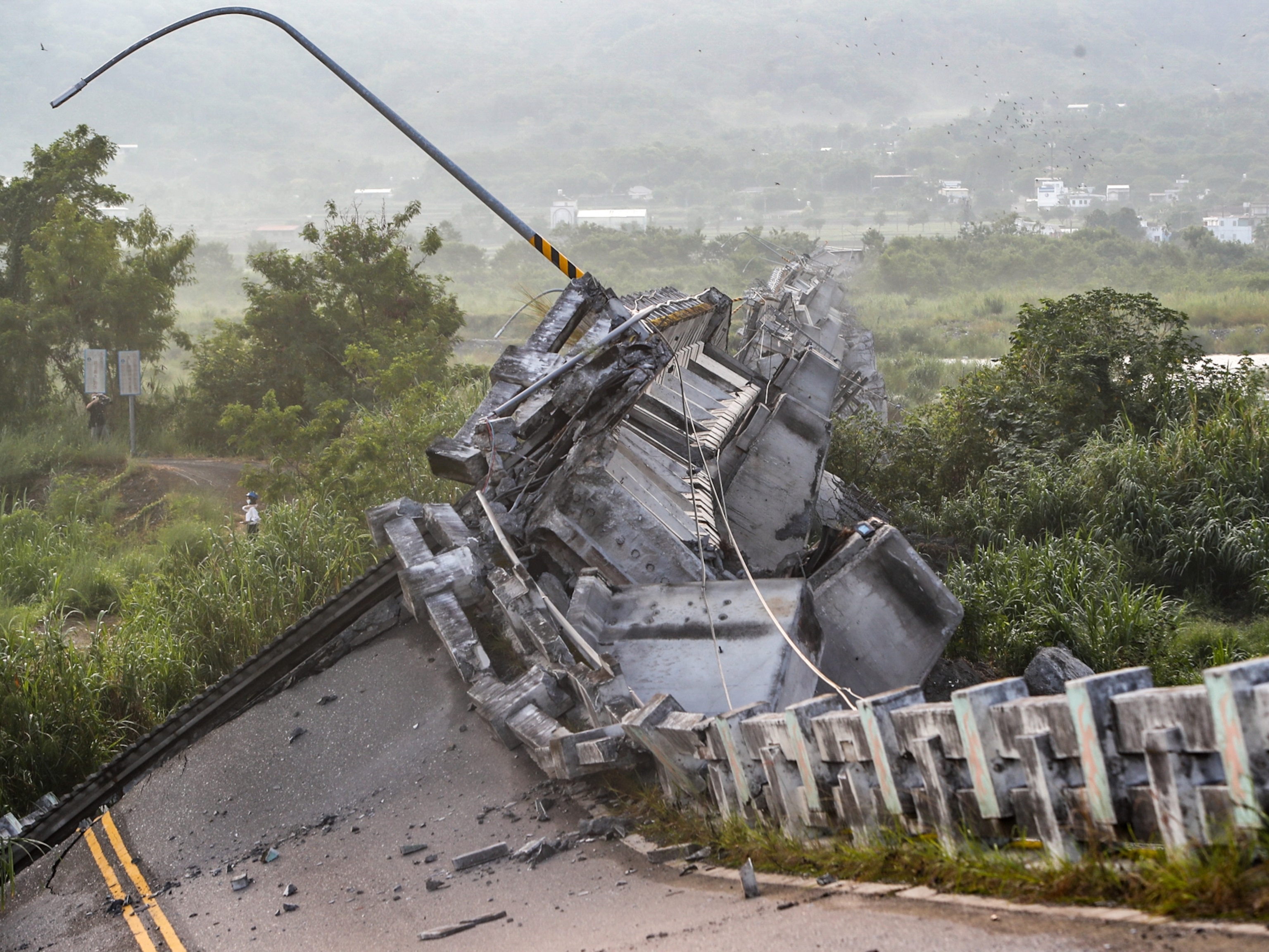
Many communities in the United States are threatened by near-source tsunamis, but few evacuation studies have been conducted to evaluate the ability of at-risk individuals to reach higher ground before tsunami waves arrive. For example, local earthquakes that generate near-source tsunamis have the potential to impact roads, infrastructure such as bridges, or facilities essential for response efforts. Preparedness efforts would greatly benefit from assessing how these earthquake damages impact the ability to evacuate. Without such information, emer-
gency managers are not able to identify where targeted outreach and evacuation assistance will be needed.
Recommendation: For all communities with near-source tsunami threats, the NTHMP should conduct evacuation modeling studies to assess the likelihood of successful evacuations.
PREPARING IN ADVANCE THROUGH A CONSISTENT PUBLIC EDUCATION CAMPAIGN
Surviving a tsunami depends on the ability of an individual in the hazard zone to recognize warning signals, make correct decisions, and act quickly. For near-field tsunamis, waves will arrive within minutes after generation; therefore, at-risk individuals will need to recognize natural cues such as the ground shaking or the receding of the water line as the primary warning. Knowledge and readiness gained through pre-event education may save lives. For far-field tsunamis, waves will arrive several hours after generation, and individuals need to understand official warnings and follow instructions given by local agencies. Regardless of the tsunami source, integrated public education and preparedness planning are necessary to protect lives and to make tsunami knowledge commonplace and ingrained into local culture and folk wisdom.
Educating At-Risk Individuals
Tsunami education in U.S. coastal communities is a major challenge because it requires reaching hundreds of coastal communities with hundreds of thousands of residents, employees, and tourists. The NTHMP Mitigation and Education Subcommittee is charged with assessing tsunami education needs for the nation, addressing these needs through targeted products and activities, and then sharing these products with other at-risk coastal areas.
Tsunami outreach and educational programs can draw from a rich base of research on enhancing hazard education to motivate the public to prepare for future hazards. For example, research has shown that training campaigns and the dissemination of education products are more effective when tailored to the strengths and vulnerabilities of specific communities. A campaign designed for long-time residents would capitalize on familiarity of the surroundings, as well as emphasize household preparation strategies and the importance of creating community networks. In contrast, a program designed for tourists and other transient populations would focus on easily identifiable landmarks, would provide information via signs posted in prominent locations, and would train hotel and tourist services staff such as tour guides, life guards, and vendors to provide assistance to tourists.
The committee was requested to review the availability and adequacy of tsunami education and outreach. One obstacle to this task was that no systematic evaluation of U.S. tsunami education efforts has been conducted at a national scale. No compilation or inventory of
NTHMP-related tsunami efforts was available at the time of this review, although it is a current goal of the NTHMP. A second obstacle is a lack of pre- and post-outreach evaluations and post-event assessments. Because there are few studies that documented the perceptions, knowledge, and capacity to prepare at-risk populations, there are no consistent baselines or metrics to gauge the effectiveness of education programs.
The committee concludes that current tsunami education efforts are not sufficiently coordinated and run the danger of communicating inconsistent and potentially confusing messages.
Recommendation: To increase the effectiveness of tsunami education, the NTHMP should
develop consistent education efforts among its members using evidence-based approaches,
tailor tsunami education to local circumstances,
create and maintain an online repository of education efforts,
develop and implement an evaluation program of the effectiveness of education efforts, and
leverage hazard-education efforts and expertise of other NOAA entities.
Because pre-event education is critical to saving lives during a near-field tsunami, the committee concludes that tracking progress in education and outreach efforts in communities threatened by near-field tsunamis is a high priority.
Recommendation: The NTHMP should prioritize systematic, coordinated perception and preparedness studies of communities with near-field tsunami sources to determine whether at-risk individuals are able to recognize natural cues of tsunamis and to take self-protective actions.
Preparing Communities
Because of the breadth and diversity of actions that could be taken to increase preparedness, the committee restricted its review of community preparedness to NOAA’s TsunamiReady Program, which has emerged in recent years as a framework for improving tsunami preparedness in coastal jurisdictions. TsunamiReady is a voluntary program that aims to help communities reduce the potential impacts from tsunami-related disasters through redundant and reliable warning communications, better preparation through community education, and official readiness through formal planning and exercises. It sets minimum guidelines, such as having the ability to communicate warnings to the local population, and encourages consistency in educational materials. Traditionally, the program has measured its success by the number of communities recognized as TsunamiReady annually. However, the committee questions the effectiveness of the program and its success criteria, because the program lacks the following elements:
a professional standard to guide its development,
metrics to assess baseline readiness and community needs,
evaluative criteria to assess community performance during a tsunami,
accountability measures to ensure recognized communities meet and continue to meet mandatory requirements,
local points of contact with training in community preparedness, and
criteria and guidance on what constitutes effective public outreach and preparedness efforts.
The Emergency Management Accreditation Program (EMAP) aims to improve community preparedness for natural hazards. Unlike TsunamiReady, EMAP is more broadly geared to all-hazards mitigation. EMAP is the nationally recognized standard for emergency management and provides criteria to assess current programs or to develop, implement, and maintain a program to mitigate, prepare for, respond to, and recover from disasters and emergencies. Its process for accreditation is transparent and applied through peer review. Because TsunamiReady’s current requirements are not well structured and do not fit the concept, terminology, and format of a standard, the program could improve by drawing on EMAP’s well-established standard, process, and experience with the emergency management community.
Recommendation: The NOAA Tsunami Program could strengthen the TsunamiReady Program by modeling it after the Emergency Management Accreditation Program.
Developing and Delivering Effective Warning Messages
The likelihood of individuals responding to tsunami warnings depends on the quality, clarity, and accuracy of the official warning messages they receive from the two Tsunami Warning Centers (TWCs) and/or local and state emergency management agencies. An effective message contains the necessary information to motivate individuals to take self-protective action and must reach at-risk people in a timely fashion. It is critical that warning messages: are accurate and consistent; use language that allows a person to visualize the proper response; make clear when recommended actions should begin and finish; identify who needs to evacuate and who does not; and explain how taking the protective action will reduce the pending consequences of not taking action at all.
Currently, both the TWCs issue a tsunami warning, advisory, watch, and information statement through multiple official channels following detection of a tsunami-triggering event. It then becomes the responsibility of local or state officials to take the appropriate actions and issue their own messages and evacuation orders to individuals in tsunami-prone areas. The generation of two different tsunami warning messages has created confusion among the media, some local officials, and the general public, and will likely continue to do so unless message content is improved or a single message is issued.
Recommendation: If distinct messages are to be produced by the two TWCs, then the messages should be consistent. Ideally, the committee recommends that one message be released by the two TWCs that includes information for all areas under their responsibility.
Recommendation: The NOAA/National Weather Service (NWS) should better integrate the TWC warning functions with the state, county, and city warning functions with regard to message content and dissemination methods for the public by developing formal TWC outreach plans and assessing needs and priorities of TWC customers.
Coordinating Across All Levels of Government
State working groups, regional groups, and the NTHMP facilitate the coordination and planning across jurisdictional boundaries, including the coordination of educational efforts and opportunities to provide feedback to the TWCs on warning messages. These efforts are valuable in contributing to pre-event planning and coordination, but they could be strengthened through additional exercises and drills focused on improving evacuation procedures during an event.
Current efforts to practice evacuation procedures and protocols include community-led evacuation drills, live code “end-to-end” tests, table-top exercises among emergency management agencies, and functional exercises to test interagency communication and coordination. The committee concludes that the importance of these approaches vary based on local conditions and tsunami threat, and include specific conclusions for both far-field and near-field tsunamis.
Far-field tsunami threats: Evacuations will be managed by multiple agencies over many hours; therefore, exercises are important to engage agencies to discuss and test coordination and communication. However, the committee concludes that evacuation drills are not advisable because of the risks associated with such drills, especially in larger communities.
Near-field tsunami threats: Initial evacuations will be self-directing after at-risk individuals recognize natural cues. The committee concludes, however, that table-top and functional exercises are still important because of the significant response and relief operations after the initial tsunami wave arrives. The committee concludes that these community-led, voluntary drills may be useful in promoting tsunami awareness, providing social cues, and building social networks but only in small communities that have limited vertical-evacuation options and may have less than 30 minutes to evacuate.
Recommendation: The NTHMP should actively encourage member states to develop and maintain active tsunami working groups to help facilitate and coordinate tsunami education, preparedness, and warning dissemination.
Recommendation: To ensure that managed evacuations for far-field tsunamis are effective and minimize societal and economic interruptions, the NTHMP should develop guidelines on the design of effective exercises for use by emergency management agencies.
Considering their multiple responsibilities and limited resources, the TWCs should be commended for their commitment to establishing connections with external groups and coordinating their efforts. However, relatively few staff resources have been dedicated to maintaining partnerships with customers, and existing efforts are secondary to the technical aspects of the warning centers. There are no formal outreach plans for media training or working with emergency management and response personnel, no formal training interaction for TWC watchstanders and state emergency management officials, and no formal standard operating procedures for evaluating the effectiveness of warning message content or channels. Retrospective reviews could enhance the effectiveness of the ongoing educational efforts and guide further improvements in community preparedness and coordination among decision makers.
Recommendation: After a significant tsunami warning is issued to U.S. communities (e.g., the 2010 Chilean event), the NOAA/NWS should initiate an independent review of TWC actions and its integration with its partners and customers through an external science review board and make findings public.
DETECTING AND FORECASTING TSUNAMIS
The two separate Tsunami Warning Centers monitor seismic activity to assess the potential for tsunami threats from earthquakes. The content of the first tsunami information statement, advisory, watch, or warning from the TWC is decided solely on seismic parameters and the historical record, if any, of past tsunamis generated in the area of the earthquake. Based on their own data analysis, the TWCs independently decide whether to issue alerts to the emergency managers in their respective areas of responsibility. This initial statement can be issued within 5-10 minutes after the earthquake is detected and might provide communities near the source with the only alert, if waves reach shore within minutes. However, this indirect seismic method has limited accuracy in its estimates of the strength of the tsunami. Because forecasters must err on the side of caution when human lives are at stake, the TWCs use conservative criteria for issuing advisories, watches, or warnings, which can lead to unwarranted evacuations costing millions of dollars.
Data from coastal sea level gauges and the open ocean DART network provide the only means to verify the existence of a tsunami and to forecast the height of the tsunami waves as they spread from the source. This information is used to adjust or cancel warnings, watches, and advisories. Coastal and open ocean sea level sensor networks can also detect tsunamis from sources that fail to generate seismic waves. Although the detection of the open ocean signal can occur within the first hour after the tsunami, forecasts might take longer. Thus, only communities farther from the tsunami source will benefit from these refined warning messages.
The committee concludes that the global networks that monitor seismic activity and coastal and open-ocean sea level variations remain essential to the tsunami warning process. The current global seismic network is adequate and sufficiently reliable for the purposes of detecting likely tsunami-triggering earthquakes. However, because the majority of the seismic stations are not operated by the TWCs, the availability of this critical data stream is vulnerable to changes outside of NOAA’s control.
The complex seismic processing algorithms used by the TWCs, given the availability of seismic data, quickly yield adequate estimates of earthquake location, depth, and magnitude for the purpose of tsunami warning. However, the methodologies are inexact, in part because of the physically variable nature of tsunamis, and in part because of the need for rapid determination of earthquake parameters that may not be definitive until the entire rupture process is complete (potentially tens of minutes). In the case of a very large earthquake the initial seismological assessment, although adequate for most medium-sized earthquakes, can underestimate the earthquake magnitude and lead to errors in assessing tsunami potential. In parallel to their own analyses, staff at the TWCs could avail themselves of earthquake locations and magnitudes that are estimated within minutes of an event from the USGS National Earthquake Information Center (NEIC). An interagency agreement could be established to make these initial estimates available on secure lines between the USGS and NOAA.
Recommendation: NOAA and the USGS could jointly prioritize the seismic stations needed for tsunami warnings to advocate for the upgrade and maintenance of the most critical stations over the long term.
Recommendation: The TWCs should work jointly with NEIC to test the utility of the W-phase algorithm in the tsunami warning process, using both a sufficient dataset of synthetic seismograms and a set of waveforms from past great earthquakes, paying particular attention to the algorithm’s performance during “tsunami earthquakes” and to the assessment of a lower-magnitude bound for its domain of applicability.
Detection of Tsunamis with Sea Level Sensors
A majority of the funds authorized by the Tsunami Warning and Education Act (P.L. 109-424) have been used to manufacture, deploy, and maintain an array of 39 DART stations, establish 16 new coastal tide gauges, and upgrade 33 existing water level stations. These new and upgraded sea level stations have closed significant gaps in the sea level sensor network that had left many U.S. coastal communities subject to uncertain tsunami warnings. The availability of these open-ocean DART stations makes it possible to forecast the height of tsunamis once waves are detected by the buoy and before they arrive onshore.
However, some fundamental issues remain. For example, gaps in coverage exist in the Caribbean region or off the South America coast. Most concerning is the committee’s finding that as much as 30 percent of DART stations are inoperable at any given time. These high
numbers for buoy outages jeopardize the ability of the TWCs to forecast tsunamis. Because the value of individual components in the network and the risk to the warning capability due to individual component failures has not been evaluated, the National Data Buoy Center (NDBC) has no guidance for high-priority buoy repairs.
Recommendation: The reliability of the DART network should be improved to allow the TWCs to fully utilize the capability this technology offers.
Recommendation: In order to bring NDBC into compliance with P.L. 109-424, the center should engage in a vigorous effort to improve the reliability of the DART stations and minimize the gaps caused by outages.
Recommendation: NOAA should regularly assess the appropriate spatial coverage of the coastal and DART sea level sensor network (U.S. and international).
Recommendation: NOAA should prioritize the sea level stations (both U.S. and international) according to their value to tsunami detection and forecasting for the areas of responsibility of the TWCs.
Recommendation: NOAA should assess on a regular basis the vulnerabilities to, and quality of, the data streams from all elements of the sea level sensor networks, beginning with the highest priority sites determined per the recommendations above.
Recommendation: NOAA should encourage access to the DART platform by other observational programs, because the platform presents an opportunity to acquire a long time series of oceanographic and meteorological variables.
Recommendation: NOAA should establish a “Tsunami Sea Level Observation Network Coordination and Oversight Committee” to oversee and review the implementation of the recommendations provided above.
Tsunami Forecasting
The expansion of the coastal and open-ocean sea level network has made it possible to forecast tsunamis in near-real time. It provides emergency managers with critical information about the time the first wave might arrive, the duration during which waves will continue to arrive (which can be for many hours), and the size of these waves. Currently, one forecast model is fully operational and one is being used by the TWCs as an additional source of forecast model output. Although these models have been relatively successful in forecasting recent events, a more open and transparent process is needed to evaluate model performance and how the results of the two models can be used to improve the results. For example, the
National Hurricane Center (NHC) runs ensemble models to take advantage of several model outputs to create a single product for the forecast. Tsunami forecasting would benefit from the development of a process that identifies (1) benchmarks to evaluate model performance, (2) how different solutions can be used to create a single forecast, and (3) how field data can be used to validate and improve the models.
Recommendation: Both the TWCs and the NOAA Center for Tsunami Research should continue to work together to advance current forecasting methodologies and bring all available methodologies into full operational use.
Future Research and Technology Development
Currently, given the distance of the source to the closest coastal or open-ocean sea level sensor, it can take up to an hour or more to confirm a tsunami forecast and potentially even longer to forecast the size. This is not only of concern in the case of near-field tsunamis, but also in the event of a tsunami earthquake or underwater landslide, events that generate only a small amount of ground shaking but could trigger a tsunami of much greater amplitude than would be expected. In this circumstance, official warnings may be the only way to notify people. An example comes from the Meiji Sanriku tsunami of 1896 in northeast Japan. The earthquake was large (magnitude 7.2) but generated such weak ground shaking that few people were concerned about the potential for a tsunami. More than 22,000 people perished in the huge tsunami that followed.
To detect a tsunami earthquake or underwater landslide, direct measurements of the water-surface variations and currents are required in real time. This rapidly sampled data could also help issue warnings to communities a little farther away from the source. Infrastructure such as sea level sensor networks and communications equipment could be destroyed by the initial impact of the tsunami wave, leading to a lack of official warnings.
One way to accomplish real-time measurements is to collect data using cabled seafloor observatories. These comprise various sensors connected to each other and to shore by a seafloor communications cable that serves both to deliver power to the sensors and to transmit data from the sensors back to onshore data servers. Several types of instruments are useful for tsunami detection, including bottom pressure sensors, seismometers, current meters, and accelerometers. Observatories currently in operation include the North-East Pacific Time-Series Underwater Networked Experiments (NEPTUNE) Canada, off the coast of British Columbia and the Monterey Accelerated Research System (MARS) in Monterey Bay, California. Another large U.S. observatory, the Ocean Observatories Initiative (OOI), has been funded by the National Science Foundation (NSF) for deployment across Oregon’s continental shelf, slope, and the Cascadia Subduction Zone, over the Juan de Fuca plate, and on the Juan de Fuca Ridge. The committee concluded that tsunami detection, warning, and preparedness activities for near-and mid-field tsunamis could benefit from the expansion of existing alternative technologies for real-time detection.
Recommendation: To develop more rapid and accurate warnings of local tsunamis, the TWCs should coordinate with the NEPTUNE-Canada and OOI observatory managers to obtain access to their seismic and bottom pressure data in near-real time. Data interpretation tool(s), jointly applied to the seismic and bottom pressure data, should be developed to realize the most rapid tsunami detection possible.
Another promising area of research that could improve the ability to more rapidly predict the magnitude of a tsunami comes from Global Positioning System (GPS) measurements. In combination with seismic data, continuous GPS measurements have proven to be powerful in studying continental earthquakes such as illuminating the processes of earthquake after-slip. Continuous GPS can provide a map of the three-dimensional deformation of the earth’s surface as a result of the earthquake rupture. This information can be used to help predict tsunami generation and provide accurate forecasts of wave heights.
The use of GPS holds great promise for extending the current seismic networks to include capabilities for measuring displacements in the coastal environments for the large earthquakes that can be underestimated using seismic techniques alone. Displacements onshore could potentially be used to infer offshore displacements in times as short as five minutes in an area such as the Cascadia fault zone.
Recommendation: NOAA should explore further the operational integration of GPS data into TWC operations from existing and planned GPS geodetic stations along portions of the coast of the U.S. potentially susceptible to near-field tsunami generation including Alaska, Cascadia, the Caribbean, and Hawaii. Where GPS geodetic coverage is not adequate, NOAA should work with NSF and the states to extend coverage, including the long-term operation and maintenance of the stations.
The report identifies several other areas of research and technology development that have the potential to improve the nation’s ability to detect, forecast, and provide timely and accurate warnings regarding tsunamis. For example, the seismic analysis could be improved using high-frequency P-waves. In addition, satellite altimetry or island seismometers might be used to detect tsunami waves, or GPS satellites could detect tsunami waves in the atmosphere. These research avenues hold promise but are far from becoming operational in the tsunami detection and warning process.
Regular, independent scientific review of the various elements of the tsunami warning system would be valuable in identifying and addressing research needs and in ensuring the effective implementation of new technologies and protocols. Science needs to be brought to bear more systematically across the spectrum of tsunami preparation, education, detection, and warning systems. The establishment of an external science advisory panel consisting of physical and social scientists, and practitioners in emergency management, is one option to provide advice and oversight across the spectrum of tsunami efforts.
IMPROVING TSUNAMI WARNING CENTERS’ RELIABILITY AND SUSTAINABILITY OF OPERATIONS
The TWCs provide services to a wide community that includes emergency managers, the scientific community, and the public. They are responsible for gathering information from sensor and observational systems, detecting tsunamigenic earthquakes, developing decision support information, and providing and disseminating warnings to the public and other entities. Although operational procedures for earthquake detection are similar at both TWCs, the technologies used are considerably different, with different hardware platforms, software suites, processes, and interfaces to the public and their users. The committee concludes that these differences lead to technological incompatibilities and limited capabilities for back up, redundancy, and checks and balances, which are important mission capabilities for the tsunami warning system.
The success of the TWC mission is critically dependent on technical infrastructure and human capital, both of which the committee assessed to be insufficiently supported. Several issues have been identified that are associated with the reliance on dated software technology hampering easy interfacing with current network and mobile data structures. Addressing these problems is difficult for the TWCs, as most scientific personnel and watchstanders have training in the geophysical sciences and not in software engineering.
To harmonize software and hardware suites, NOAA developed an information technology (IT) Convergence Plan, with the goal of creating a single, platform-independent technology architecture to be deployed at each TWC and a shared tsunami portal. The committee believes that the NOAA’s IT Convergence Plan is well-motivated, but it notes that the plan is a single project effort and is not part of a systematic, comprehensive IT system plan and enterprise architecture.
Recommendation: The NOAA/NWS should harmonize and standardize checklists, tsunami warning products, and decision support tools, and it should use standard TWC software tools and applications.
Recommendation: Given the importance of IT and the rapid evolution of IT, the tsunami warning program should undertake a comprehensive, enterprise-wide long-range technology planning effort, consistent with international technology process and product standards, in order to develop both an enterprise-wide technology architecture for TWC operations and the accompanying enterprise-wide technology support processes.
As part of this long-range planning effort NOAA/NWS should:
consider providing the TWCs with stronger IT commitment and leadership, and greater resources for software and hardware personnel, planning, development, operations, maintenance, and continuous process and product improvement.
provide sufficient IT staff to the TWCs so that IT hardware and software design, development, and maintenance are not a collateral duty of a watchstanding scientist, as is the case presently.
adopt national, and where applicable, international, standards, best practices, and lessons learned for all functions, technology, processes, and products.
regularly and systematically apply continuing process and product improvement models for hardware and software planning, development, operations, and maintenance and for organizational processes; and develop a learning organizational culture.
The committee reviewed the pre-written messages delivered by the TWCs and found that many documented principles for effective warning messages have not been applied. The committee concluded that the centers’ warning products would be much more effective if their content and delivery incorporated the latest social science on composing effective warning messages and were compatible with current software, hardware, and social media.
Recommendation: The TWCs should consider alternative warning message composition software and should improve protocols by undertaking an external review by IT specialists in the area of communication technology to identify the latest technology in message composition software and formats to ensure compatibility with current and next generation information and communication technology for message dissemination.
The committee also found inconsistencies between the warning products of the TWCs and those of the NWS. For example, a watch means that an event has an 80 percent chance of becoming a warning in the NWS, but this is not the case with the TWCs whose watches rarely become warnings. Another current inconsistency is how the TWCs and the NWS deal with “all-clears.” The TWCs cancel a bulletin, which could be read by the public as a signal that it is safe to return, which is not the same as an “all-clear” issued by the NWS. The NWS will soon move from using the “alert bulletin system” to an “impact based system,” which will introduce another inconsistency with the TWCs.
Recommendation: Current and future adjustments of TWCs and NWS warning products should be made in a consistent fashion. A mechanism should be put in place so that future changes in warning products are quickly reviewed for inconsistencies, which are then addressed, so that products from the TWCs and the NWS match.
Human Resources
Each TWC relies on a dedicated staff, including nine science duty officers that perform watchstanding duties in addition to research and development. The watchstander has a critical role in tsunami decision support by maintaining situational awareness and issuing correct notification and warning products. Although visualization software assists by monitoring seismic and sea level data and mapping event locations, it is the watchstanders’ training, experience, and expert judgment that are essential in making the appropriate decisions when creating warning products. To enhance the effectiveness of TWC decision making and the TWC staff’s ability to inform decision making processes, regular and varied types of training are needed. In addition, because of the importance of technical and scientific know-how within
the TWCs, opportunities for interactions between TWC staff and external scientific and professional communities are important and need to be encouraged and institutionalized within the tsunami program.
Recommendation: Because of the importance of technical and scientific expertise to the TWC’s function, TWC human capital requirements, recruiting, training, re-training, development, mentoring, and professional exchange should be included, reassessed, and updated as part of the NOAA/NWS enterprise-wide technology planning effort.
Organizational Structure
The goal of having two geographically distributed TWCs in Hawaii and Alaska with distinct areas of responsibility is to provide the system with backup in the case of critical failure at the other center. However, there are significant differences in IT architecture and software suites that thwart this backup function. Also, inconsistencies in warning products issued by the two TWCs have caused confusion. Because clear communication and consistency in message content are two key principles to effective warning message composition, the TWCs’ warning products are less effective in eliciting the appropriate response. Because the TWCs are managed by two different regional NWS offices, use different analytical software and hardware, and appear to have distinct organizational cultures, the committee concludes that they do not function as redundant systems. Significant organizational changes will be needed to allow them to truly function as redundant systems that provide true backup capabilities. The committee considered the following options to address shortcomings of the current structure of the TWCs: harmonizing the two TWCs’ operations, merging the two TWCs into a single center, or co-locating one or more TWCs with other research or forecasting units.
Recommendation: Organizational structures for the two TWCs should be evaluated and fully described as part of an enterprise-wide technology planning effort. Whether there should be a single or multiple TWCs, or whether the TWC operations should be consolidated in a different location, should be addressed during the enterprise-wide long-range planning effort.
Conclusions
The numerous distributed efforts in tsunami detection, warning, and preparedness are linked together to reduce loss of life and economic assets from a tsunami. In the event of a tsunami, all these distributed efforts must come together in less than a day to produce an effective, adaptable response and function like a single organization. A challenge for tsunami warning preparedness efforts is to develop effective organizational structures that provide reliable and sustainable operations in non-tsunami periods as well as during catastrophic incidents, especially given the short time available to respond in a crisis.
The committee found that personnel responsible for these efforts (e.g., at the TWCs and Tsunami Program, state emergency managers, etc.) are highly committed to serving each of the program’s functions, from detection through education and community outreach. However, the committee found many shortcomings of the TWCs in terms of function, technology, human capital, and organizational structures, and many opportunities for significant improvements in center operations. Improvements will depend upon an organizational culture change within the NOAA/NWS Tsunami Program that supports and celebrates operational excellence, adopts national and international standards, processes, best practices, and lessons learned for all functions, technologies, processes, and products, and continuously seeks process improvements.
Recommendation: Tsunami warning system processes and products should reflect industry best practices, as well as lessons learned from other operational real-time, large-scale, mission-critical distributed systems, and should comply with international information technology and software engineering product and process standards.
Recommendation: NOAA/NWS and the TWCs should undertake ongoing, joint or NOAA-wide, continuous process improvement activities for their functional, technological, organizational, and human capital initiatives.
Many coastal areas of the United States are at risk for tsunamis. After the catastrophic 2004 tsunami in the Indian Ocean, legislation was passed to expand U.S. tsunami warning capabilities. Since then, the nation has made progress in several related areas on both the federal and state levels. At the federal level, NOAA has improved the ability to detect and forecast tsunamis by expanding the sensor network. Other federal and state activities to increase tsunami safety include: improvements to tsunami hazard and evacuation maps for many coastal communities; vulnerability assessments of some coastal populations in several states; and new efforts to increase public awareness of the hazard and how to respond.
Tsunami Warning and Preparedness explores the advances made in tsunami detection and preparedness, and identifies the challenges that still remain. The book describes areas of research and development that would improve tsunami education, preparation, and detection, especially with tsunamis that arrive less than an hour after the triggering event. It asserts that seamless coordination between the two Tsunami Warning Centers and clear communications to local officials and the public could create a timely and effective response to coastal communities facing a pending tsuanami.
According to Tsunami Warning and Preparedness , minimizing future losses to the nation from tsunamis requires persistent progress across the broad spectrum of efforts including: risk assessment, public education, government coordination, detection and forecasting, and warning-center operations. The book also suggests designing effective interagency exercises, using professional emergency-management standards to prepare communities, and prioritizing funding based on tsunami risk.
Welcome to OpenBook!
You're looking at OpenBook, NAP.edu's online reading room since 1999. Based on feedback from you, our users, we've made some improvements that make it easier than ever to read thousands of publications on our website.
Do you want to take a quick tour of the OpenBook's features?
Show this book's table of contents , where you can jump to any chapter by name.
...or use these buttons to go back to the previous chapter or skip to the next one.
Jump up to the previous page or down to the next one. Also, you can type in a page number and press Enter to go directly to that page in the book.
Switch between the Original Pages , where you can read the report as it appeared in print, and Text Pages for the web version, where you can highlight and search the text.
To search the entire text of this book, type in your search term here and press Enter .
Share a link to this book page on your preferred social network or via email.
View our suggested citation for this chapter.
Ready to take your reading offline? Click here to buy this book in print or download it as a free PDF, if available.
Get Email Updates
Do you enjoy reading reports from the Academies online for free ? Sign up for email notifications and we'll let you know about new publications in your areas of interest when they're released.
Effective disaster risk governance saves lives, UN highlights on World Tsunami Awareness Day
")
Facebook Twitter Print Email
Top UN officials have underscored the importance of continuous risk assessment and preparedness to safeguard coastal communities worldwide from the disastrous impact of tsunamis, marking World Tsunami Awareness Day on Thursday.
In a message , Secretary-General António Guterres cited the need for strong disaster risk governance against the rare but incredibly devastating sudden onset disasters.
Tsunamis cannot be averted, but we can prepare for them.The @UN is working around the globe to educate, organize drills, create evacuation routes and to do everything possible to avoid loss of life when the next tsunami comes. https://t.co/41EGM8pAkx #TsunamiDay pic.twitter.com/gYknTSsdnG António Guterres, UN Secretary-General antonioguterres
“When tsunamis strike, they are a supreme test of the governance and institutions that have been put in place to manage disaster risk,” he said.
Strengthening disaster risk governance would help build our resilience to “all hazards, natural and man-made,” he stressed.
World Tsunami Awareness Day, marked annually on 5 November, commemorates the actions of a Japanese village leader, who on that day in 1854, recognized the signs of an approaching tsunami and set fire to his rice sheaves – an improvised but remarkably effective early warning system – saving the lives of the many villagers who saw the smoke and ran uphill to help put out the flames.
COVID-19 ‘tsunami’
Mr. Guterres also drew parallels between tsunamis and the coronavirus pandemic, in their impact on lives.
“We are struggling with what some describe as a tsunami of death and disease due to COVID-19,” he said, adding that the metaphor comes easily because living memory remains strong of the 2004 Indian Ocean tsunami, in which more than 227,000 people perished.
“Pandemic preparedness can borrow much from the progress we have made in reducing large-scale loss of life from tsunamis,” he added.
Mami Mizutori, Special Representative of the Secretary-General for Disaster Risk Reduction, echoed these words.
“What is true for this biological hazard is true for many other hazards man-made, natural and technological that are threatening our planet,” she said.
Getting the plans right
Ms. Mizutori, who also heads the UN Office for Disaster Risk Reduction ( UNDRR ), also emphasized the importance of disaster risk governance.
“Clear vision, guidance, coordination and competence are essential to the success of raising tsunami awareness around the world. Lives will be saved, injuries reduced, and economy spared if we get the planning right … Prevention saves lives,” she said.
Similarly, Audrey Azoulay, Director-General of UN Educational, Scientific and Cultural Organization (UNESCO), also called for continuous risk assessment and preparedness, especially given that the risks are compounded by the effects of climate change.
“Governments, partner organizations and civil society need to support and facilitate these crucial disaster reduction activities,” she added.
“Saving lives and protecting the livelihoods of communities at risk of tsunamis requires sustained investment in resilient infrastructure, early warning systems and education,” said Ms. Azoulay, stressing: “In this field especially, we need to build the future we want today.”
Helping communities globally
Around the world, UN works to raise awareness and educate the public, support policies, organize drills, create evacuation routes, and undertake several other activities to safeguard communities from tsunamis.
For instance in Asia and the Pacific, the UN regional commission, ESCAP , set up a trust fund for tsunami preparedness in the aftermath of the 2004 Indian Ocean tsunami. The initiative supported the establishment of the Indian Ocean Tsunami Warning System, and has expanded its scope to cover island nations in southwest Pacific.
Similarly, UNESCO ’s Intergovernmental Oceanographic Commission has helped bolster tsunami preparedness in the Caribbean – another region that suffered devastating tsunamis – through better coordination, hazard assessment, warning communication, preparedness activities, response and resilience to tsunamis and other ocean hazards.
Also, this year, with COVID-19 bringing new and complex challenges to disaster preparedness and response, UNDRR along with the UN Development Programme ( UNDP ) published a guide for school administrators to help them implement tsunami evacuation centres, should the need arise.

The World Day
In December 2015, the UN General Assembly designated 5 November as World Tsunami Awareness Day , calling on all countries, international bodies and civil society to observe the day, to raise tsunami awareness and share innovative approaches to saving lives.
This year, the World Day promotes target E of the Sendai Seven Campaign , urging governments to develop and put in place national and local disaster risk reduction strategies, by the end of 2020.
- UN International Days
Essay on Tsunami
Students are often asked to write an essay on Tsunami in their schools and colleges. And if you’re also looking for the same, we have created 100-word, 250-word, and 500-word essays on the topic.
Let’s take a look…
100 Words Essay on Tsunami
What is a tsunami.
A tsunami is a series of powerful waves caused by the displacement of a large volume of water. This usually happens due to earthquakes, volcanic eruptions, or underwater landslides.
How Does a Tsunami Form?
When the sea floor abruptly deforms, it displaces the overlying water, triggering a tsunami. The waves travel across the ocean at high speeds.
Effects of a Tsunami
Tsunamis can cause mass destruction when they hit land. They can flood cities, destroy buildings, and take lives. It’s important to have early warning systems to minimize damage.
Understanding tsunamis helps us prepare and mitigate their harmful effects.
Also check:
- 10 Lines on Tsunami
- Paragraph on Tsunami
- Speech on Tsunami
250 Words Essay on Tsunami
Introduction.
Tsunamis, deriving from the Japanese words ‘tsu’ meaning harbor and ‘nami’ meaning wave, are a series of powerful water waves caused by the displacement of a large volume of a body of water. They are known for their destructive power and unpredictability, posing a significant threat to coastal communities.
Causes of Tsunamis
Tsunamis are typically triggered by seismic activities beneath the ocean floor. These include earthquakes, volcanic eruptions, or landslides. The energy released during these events displaces the overlying water column, generating waves that can travel across oceans at high speeds.
Characteristics and Impact
Unlike regular waves, tsunami waves involve the movement of the entire water column from the sea surface to the seabed. This attribute contributes to their long wavelengths and high energy, enabling them to travel vast distances. Upon reaching shallow waters, their speed decreases, causing the wave height to increase dramatically, often resulting in widespread destruction when they hit land.
Prevention and Mitigation
While tsunamis cannot be prevented, their impact can be mitigated through early warning systems, coastal zone management, and community preparedness. Technological advancements have made it possible to detect seismic activities and issue timely alerts, thereby saving lives.
Tsunamis, while a fascinating natural phenomenon, are a stark reminder of nature’s power. Understanding their causes and characteristics is crucial in developing effective mitigation strategies, thereby reducing their devastating impacts on human lives and the environment.
500 Words Essay on Tsunami
Tsunamis, often referred to as seismic sea waves, are a series of ocean waves caused by any large-scale disturbance of the sea surface. These disturbances can include earthquakes, volcanic eruptions, landslides or even meteorite impacts in the ocean. Tsunamis are not regular sea waves but energy waves, often caused by seismic activities beneath the ocean floor. Their impact on human lives and the environment can be devastating, emphasizing the importance of understanding and predicting these natural disasters.
The Mechanics of a Tsunami
Tsunamis are initiated by a sudden displacement of the sea floor due to geological activities like earthquakes. This displacement results in a vertical shift of the overlying water column, creating a series of waves that radiate outwards from the point of origin. The speed of a tsunami is determined by the depth of water, with deeper waters facilitating faster wave speeds.
In the open ocean, these waves may be just a few centimeters high, but their wavelength, or the distance between successive crests, can span hundreds of kilometers. As these waves approach coastal areas, the shallowing sea floor compresses the wave energy, causing the wave to increase dramatically in height.
Impact and Consequences
The destructive power of a tsunami comes from the massive amount of water that it can move and the consequent flooding. When a tsunami reaches the shore, it can cause immense damage to structures, erode beaches and embankments, destroy vegetation, and severely impact both terrestrial and marine life.
The human toll can be equally devastating. Tsunamis can lead to loss of life, displacement of people, and economic damage. The aftermath of a tsunami often includes public health crises, with the spread of waterborne diseases and psychological trauma among survivors.
Unfortunately, tsunamis cannot be prevented as they are triggered by natural geological processes. However, their impact can be mitigated through early warning systems, community preparedness, and intelligent coastal management.
Tsunami early warning systems, comprising seismographs and sea level monitoring stations, can provide critical minutes to hours of warning. This allows people in the path of a tsunami to seek higher ground. Community preparedness involves education about tsunami risks, evacuation routes, and drills. Intelligent coastal management can include the construction of seawalls, planting of mangroves to absorb wave energy, and zoning laws to prevent construction in high-risk areas.
Tsunamis, while a fascinating demonstration of the power of nature, are a sobering reminder of our vulnerability to natural disasters. As our understanding of these phenomena grows, so too does our ability to protect ourselves and our communities. The implementation of early warning systems, public education, and intelligent coastal management are key components in reducing the devastating impact of these ocean giants. Through continued research and community resilience, we can mitigate the effects of tsunamis and safeguard our future against these powerful sea waves.
That’s it! I hope the essay helped you.
If you’re looking for more, here are essays on other interesting topics:
- Essay on Trekking
- Essay on Tokyo Olympics
- Essay on Titanic
Apart from these, you can look at all the essays by clicking here .
Happy studying!
Leave a Reply Cancel reply
Your email address will not be published. Required fields are marked *
Save my name, email, and website in this browser for the next time I comment.

An official website of the United States government
Official websites use .gov A .gov website belongs to an official government organization in the United States.
")
Tsunamai Hazard Zone. (Image credit: iStock)
U.S. tsunami warning system
What is a tsunami, tsunami detection and observation, tsunami forecasting and warning, tsunami preparedness, tsunami research and development.
A tsunami is one of the most powerful and destructive natural forces. It is a series of waves caused by a large and sudden displacement of the ocean. Tsunamis are a serious threat to life and property.
Most tsunamis are caused by large earthquakes below or near the ocean floor, but can also be caused by landslides, volcanic activity, certain types of weather, and near-earth objects. In the deep ocean, tsunami waves are often barely noticeable, but can move as fast as a jet plane, over 500 mph. As they enter shallow water near land, they slow down and grow in height, and currents intensify.
")
Most tsunami waves are less than 10 feet high, but can exceed 100 feet in extreme events. When a tsunami comes ashore, it may look like a fast-rising flood or a wall of water. Sometimes, before the water rushes on land, it will drain away suddenly, showing the ocean floor like a very low, low tide. A large tsunami can flood low-lying coastal areas more than a mile inland. The first wave may not be the largest or most damaging. Waves may repeatedly flood and recede from the land for many hours.
—Number of tsunamis since the beginning of the 20th century that collectively caused more than 500 deaths in the United States and more than $1.7 billion in damage to U.S. coastal states and territories.
A tsunami can be very dangerous to life and property on the coast. It can produce unusually strong currents, rapidly flood the land, and cause great destruction. The flow and force of the water and debris it carries can destroy boats, vehicles, and buildings; cause injuries; and take lives as the tsunami moves across land and returns to the sea. Dangerous currents and flooding may last for days. Even small tsunamis can be dangerous. Strong currents can injure and drown swimmers and damage or destroy boats in harbors.
Published on Nov 4, 2015 On March 11, 2011 a 9.0 magnitude earthquake off the Pacific coast of Japan generated a tsunami. This series of ocean waves sped towards the island nation with waves reaching 24 feet high. The result was devastation and utter destruction.
Tsunamis can strike any U.S. coast , but risk is greatest for states and territories with Pacific and Caribbean coastlines. Low-lying areas such as beaches, bays, lagoons, harbors, river mouths, and areas along rivers and streams leading to the ocean are the most vulnerable. Tsunamis can happen any time, any season. They can be generated far away (across the ocean) or locally. Local tsunamis can arrive just minutes after generation.
To detect and observe tsunamis as they move across the ocean, NOAA depends on networks of seismic and sea-level observation systems. These networks are owned and operated by a number of domestic and international organizations, including NOAA.
The NOAA Tsunami Program runs the U.S. Tsunami Warning System. This includes monitoring for tsunamis and the earthquakes that cause them to provide timely and accurate tsunami messages. NOAA’s success in fulfilling this important mission relies on the ability to quickly detect a tsunami, which is accomplished through networks of advanced observation systems.
3 feet or less
—Typical size of tsunami waves in the deep ocean. Ships at sea may not even notice tsunami waves as they pass beneath their hulls.
NOAA operates two tsunami warning centers , which are staffed 24 hours a day, 7 days a week. The National Tsunami Warning Center serves the continental United States, Alaska, and Canada. The Pacific Tsunami Warning Center directly serves the Hawaiian Islands, the U.S. Pacific and Caribbean territories, and the British Virgin Islands and is the primary international forecast center for the Pacific and Caribbean.
When an earthquake occurs, seismic networks provide information about its location, depth, and magnitude to help the warning centers determine if it may have generated a tsunami and if they should issue tsunami messages. The U.S. Geological Survey and its partners operate the primary U.S. seismic networks.
If the earthquake meets certain criteria, the warning centers use sea-level data to determine the existence of a tsunami and refine or cancel messages. NOAA has established and maintains two essential sea-level observation networks.
")
NOAA’s National Data Buoy Center operates and maintains the U.S. network of Deep-Ocean Assessment and Reporting of Tsunami (DART) systems, which were developed by NOAA’s Pacific Marine Environmental Laboratory for the early detection, measurement, and real-time reporting of tsunamis in the open ocean. The U.S. network is part of a larger international network.
Closer to shore, networks of coastal water-level stations are used to confirm tsunami arrival time and height. In the United States, most of these stations are operated and maintained by NOAA’s Center for Operational Oceanographic Products and Services . Several others are operated by the tsunami warning centers.
")
NOAA’s Tsunami Warning Centers use tsunami forecast models combined with data from the seismic and sea-level networks to continuously refine their messages with more accurate, targeted, and detailed information.
If an earthquake meets certain criteria, the warning centers issue U.S. messages (alerts) through multiple channels to emergency managers, other officials, news media, and the public. They issue threat messages to international partners in the Pacific and Caribbean to help them understand the threat to their coasts so they can determine the level of alerts to issue.
There are four levels of tsunami alerts in the United States: Information Statement, Watch, Advisory, and Warning. When the centers issue Tsunami Warnings, they are broadcast through local radio and television, wireless emergency alerts , NOAA Weather Radio and NOAA websites (like Tsunami.gov ). They may also come through outdoor sirens, local officials, text message alerts, and telephone notifications.
—The approximate number of tsunamis from 2000 B.C. to the present in the global historical tsunami database.
If a tsunami is detected, the warning centers run tsunami forecast models developed by NOAA’s Pacific Marine Environmental Laboratory and the warning centers. These models use real-time information from the observation systems and pre-established scenarios to simulate tsunami movement across the ocean and estimate coastal impacts, including wave height and arrival times, the location and extent of coastal flooding, and event duration.
")
The resulting forecasts, combined with historic tsunami data and additional seismic analysis, help the warning centers decide whether to cancel messages or adjust them. In the United States, these forecasts also provide local officials with actionable information that can guide decisions about population evacuation, including pedestrian and traffic routes and beach and road closures. To support forecast and warning capabilities, NOAA’s Center for Coasts, Oceans, and Geophysics develops high-resolution coastal digital elevation models, which depict Earth’s solid surface. The center also serves as the long-term archive for national and international tsunami data, a natural hazards image database , and the global historical tsunami database . It is used to identify regions at risk, validate tsunami forecast models, help position DART systems and coastal water-level stations, and prepare for future events.
Of all Earth’s natural hazards, tsunamis are among the most infrequent. Even though most are small and nondestructive, tsunamis pose a major threat to coastal communities. People who live, work, or play at the coast should prepare for a tsunami.
Although tsunamis cannot be prevented, there are things that communities and the public can do before, during, and after a tsunami that can save lives. A comprehensive and effective warning system requires that communities and individuals are prepared to respond to tsunamis and have taken steps to reduce potential impacts.
This fast draw video from NOAA explains how to prepare for and respond to a tsunami. If you live, work, or play on the coast, be prepared and stay safe! Learn more about tsunamis and tsunami safety: http://www.weather.gov/tsunamisafety.
— Number of TsunamiReady communities in March 2017 .
In the United States, much of this work is conducted through the National Tsunami Hazard Mitigation Program (NTHMP), a federal/state partnership led by NOAA that also includes the Federal Emergency Management Agency , the U.S. Geological Survey , and 28 U.S. states and territories. The NTHMP works to reduce the impact of tsunamis through preparedness and mitigation activities that include public outreach and education, community planning (e.g., evacuation and land-use), hazard assessment, and warning guidance. Established in coordination with the NTHMP, NOAA’s TsunamiReady program helps communities prepare for tsunamis and minimize tsunami-related losses through better planning, education, and awareness. The program is voluntary, and communities must meet certain guidelines to be recognized as TsunamiReady.
National Weather Service Forecast Offices work with communities to support their tsunami preparedness efforts and help them become TsunamiReady. They also support the NOAA Tsunami Program by educating the public, local officials, and the media about tsunamis and tsunami safety .
")
NOAA also provides education and preparedness services to international partners in the Pacific and the Caribbean through the International Tsunami Information Center offsite link and the Caribbean Tsunami Warning Program , respectively.
NOAA’s efforts to build a comprehensive tsunami warning system have resulted in a nation better equipped to detect and respond to tsunamis. Through its research efforts, NOAA continues to make advances in tsunami detection, observing, forecasting, and warning to improve the timeliness, accuracy, and accessibility of alerts.
NOAA is a global leader in the development of tsunami detection technologies and modeling tools. While significant efforts were underway to detect and model tsunamis prior to the 2004 Indian Ocean tsunami, the event spurred the development of a national tsunami research to operations plan.
$200 million
—Amount saved by avoiding unnecessary evacuations in Hawaii since the Indian Ocean tsunami, thanks to improved forecasting.
The U.S. tsunami warning system has come a long way in recent years. Continued investments to advance the technology and strengthen partnerships have resulted in a robust and effective system, but more remains to be done to ensure the delivery of the best messages possible. NOAA is constantly developing new and improved technologies and tools to better safeguard coastal communities. Current research efforts are addressing the science-based needs of the tsunami warning centers and aim to identify, develop, and rapidly transition technologies and modeling tools into tsunami warning center operations.
These efforts include refining tsunami detection technologies to improve capability and reduce production and operating costs. A fourth generation DART system (4G) has been undergoing testing since 2013. Like the earlier systems, the DART 4G system will detect and measure both distant and local tsunamis but will be able to detect and measure a tsunami very close to the earthquake source, which will provide valuable information to warning centers faster than ever before.
")
Other examples include exploring the use of undersea fiber-optic cables and GPS-based tsunami monitoring to augment the DART network and looking at how to better detect, observe, and forecast tsunamis caused by landslides and weather-related events. In addition, NOAA depends on social science research to refine the content of its messages and outreach to encourage appropriate public response and improve the effectiveness of the warning system.
Essay on Tsunami for Students and Children
500+ words essay on tsunami.
Tsunami is a phenomenon where a series of strong waves that are responsible for the surge in water sometimes reach the heights in many meters. This is a natural disaster that is caused due to the volcano eruption in the ocean beds. Also, a phenomenon like landslides and earthquakes contributes to reasons for a tsunami. Like other natural disasters, the impact of the tsunami is also huge. It has been seen throughout history how disastrous the tsunami is. The essay on tsunami talks about various factors that contribute to the tsunami and the damage it causes to mankind.
Essay on Tsunami

The disaster that is caused due to waves generated in the ocean because of the earthquake and whose main point is under the water is known as ‘Tsunami’. Also, the term tsunami is associated with tidal waves. Thus, a tsunami is also called as the series of ocean waves that have a very long wavelength. Because of the tsunami, there are strong waves of water is formed and this moves landwards. So, this causes inland movement of water which is very high and lasts for a long time. Thus, the impact of these waves is also very high.
Greeks were the first people on Earth to claim the effects of the tsunami. They claim that tsunami is just like land earthquakes. Also, the only difference between tsunami and earthquake is that tsunami is caused in oceans. Thus, the scale and ferocity of the tsunami are almost impossible to control.
Get the huge list of more than 500 Essay Topics and Ideas
The History of Tsunami
The highest ever recorded tsunami was on 9th July 1958 in the record books. It took place in a bay which was located in the ligula bay along the coasts of Alaska. After the quake, a massive mass of rock fell into the bay waters from the cliff nearby. Thus, this created an impact and produced a wave that reached a height of 524 meters. Also, this is regarded as one of the highest recorded tsunami waves ever.
The destructive waves responsible for the occurrence of tsunami is also produced in waters of bays or lakes. As this water approached the coast, it grows larger. However, the size of this wave is very low in deep-sea areas. Tsunami waves that are generated in the lakes or bays do not travel for a long distance. Thus, they are not as destructive as the ones produced in the ocean waters. There are various directions in which tsunami can travel from the main point.
One similar devastating tsunami was experienced in India in 2004. However, the origin of this tsunami was located near Indonesia. Because of the tsunami, it was expected that a total of 2 lakh people lost their lives. The waves traveled extensively thousands of kilometers in countries like Thailand, India, Indonesia, Sri Lanka, Bangladesh, and the Maldives.
Tsunamis occur mainly in the Pacific Ocean. There are very chances that they take place in the area where there are larger bodies. Coastlines and open bays next to very deep waters may help tsunami further into a step-like wave.
Customize your course in 30 seconds
Which class are you in.

- Travelling Essay
- Picnic Essay
- Our Country Essay
- My Parents Essay
- Essay on Favourite Personality
- Essay on Memorable Day of My Life
- Essay on Knowledge is Power
- Essay on Gurpurab
- Essay on My Favourite Season
- Essay on Types of Sports
Leave a Reply Cancel reply
Your email address will not be published. Required fields are marked *
Download the App


An official website of the United States government
Here’s how you know
Official websites use .gov A .gov website belongs to an official government organization in the United States.
Secure .gov websites use HTTPS A lock ( Lock A locked padlock ) or https:// means you’ve safely connected to the .gov website. Share sensitive information only on official, secure websites.
Prepare Now
Survive During
Be Safe After
Related Content
If you are a disaster survivor, please visit FEMA.gov for up-to-date information on current disaster declarations. If you have questions about your disaster assistance application, you can call (800) 621-3362, visit disasterassistance.gov or use the FEMA mobile app .
A tsunami is a series of enormous ocean waves caused by earthquakes, underwater landslides, volcanic eruptions or asteroids. A tsunami can kill or injure people and damage or destroy buildings and infrastructure as waves come in and go out. Tsunamis can:
Travel 20-30 miles per hour with waves 10-100 feet high.
Cause flooding and disrupt transportation, power, communications and the water supply.
Happen anywhere along U.S. coasts. Coasts that border the Pacific Ocean or Caribbean have the greatest risk.
IF YOU ARE UNDER A TSUNAMI WARNING:
- If caused by an earthquake, Drop, Cover, then Hold On to protect yourself from the earthquake first.
- Get to high ground as far inland as possible
- Be alert to signs of a tsunami, such as a sudden rise or draining of ocean waters.
- Listen to emergency information and alerts. Always follow the instructions from local emergency managers.
- Evacuate: DO NOT wait! Leave as soon as you see any natural signs of a tsunami or receive an official tsunami warning.
- If you are in a boat, go out to sea.
Prepare NOW

- Learn the signs of a potential tsunami, such as an earthquake, a loud roar from the ocean, or unusual ocean behavior, such as a sudden rise or wall of water or sudden draining of water showing the ocean floor.
- Know and practice community evacuation plans. Some at-risk communities have maps with evacuation zones and routes. Map out your routes from home, work and play. Pick shelters 100 feet or more above sea level, or at least one mile inland.
- Create a family emergency communication plan that has an out-of-state contact. Plan where to meet if you get separated.
- Sign up for your community’s warning system. The Emergency Alert System (EAS) and National Oceanic and Atmospheric Administration (NOAA) Weather Radio also provide emergency alerts.
- Consider earthquake insurance and a flood insurance policy through the National Flood Insurance Program (NFIP). Standard homeowner’s insurance does not cover flood or earthquake damage.
Survive DURING

- If there is an earthquake and you are in a tsunami area, protect yourself from the earthquake first. Drop, Cover, and Hold On. Drop to your hands and knees. Cover your head and neck with your arms. Hold on to any sturdy furniture until the shaking stops. Crawl only if you can reach a better cover, but do not go through an area with more debris.
- When the shaking stops, if there are natural signs or official warnings of a tsunami, move immediately to a safe place as high and as far inland as possible. Listen to the authorities, but do not wait for tsunami warnings and evacuation orders.
- If you are outside of the tsunami hazard zone and receive a warning, stay where you are unless officials tell you otherwise.
- Leave immediately if you are told to do so. Evacuation routes often are marked by a wave with an arrow in the direction of higher ground.
- If you are in the water, then grab onto something that floats, such as a raft or tree trunk.
- If you are in a boat, face the direction of the waves and head out to sea. If you are in a harbor, go inland.
Be Safe AFTER

- Listen to local alerts and authorities for information on areas to avoid and shelter locations.
- Save phone calls for emergencies. Phone systems often are down or busy after a disaster. Use text messages or social media to communicate with family and friends.
- Avoid wading in floodwater, which can contain dangerous debris. Water may be deeper than it appears.
- Be aware of the risk of electrocution. Underground or downed power lines can electrically charge water. Do not touch electrical equipment if it is wet or if you are standing in water.
- Stay away from damaged buildings, roads and bridges.
- If you become injured or sick and need medical attention, contact your healthcare provider and shelter in place, if possible. Call 9-1-1 if you are experiencing a medical emergency.
- Document property damage with photographs. Conduct an inventory and contact your insurance company for assistance.
- Tsunami Safety Graphics
- Tsunami Information Sheet (PDF)
- Protective Actions Research for Tsunami
- NOAA Tsunami program
- American Red Cross Tsunami Preparedness
- Tsunami Safety (weather.gov)
Last Updated: 03/21/2024
Return to top

An official website of the United States government
The .gov means it’s official. Federal government websites often end in .gov or .mil. Before sharing sensitive information, make sure you’re on a federal government site.
The site is secure. The https:// ensures that you are connecting to the official website and that any information you provide is encrypted and transmitted securely.
- Publications
- Account settings
Preview improvements coming to the PMC website in October 2024. Learn More or Try it out now .
- Advanced Search
- Journal List
- Springer Nature - PMC COVID-19 Collection
Emergency response, intervention, and societal recovery in Greece and Turkey after the 30th October 2020, M W = 7.0, Samos (Aegean Sea) earthquake
S. mavroulis.
1 Department of Dynamic Tectonic Applied Geology, Faculty of Geology and Geoenvironment, National and Kapodistrian University of Athens, Athens, Greece
2 Department of Civil Engineering, Middle East Technical University, Ankara, Turkey
M. Tunçağ
3 Izmir Metropolitan Municipality, Izmir, Turkey
4 Earthquake Planning and Protection Organization, Athens, Greece
S. Püskülcü
5 Turkish Earthquake Foundation, Ankara, Turkey
6 Department of Civil Engineering, University of Bristol, Bristol, UK
M. Mavrouli
7 Department of Microbiology, Medical School, National and Kapodistrian University of Athens, Athens, Greece
M. Manousaki
N. karveleas.
On 30 October 2020, an M w = 7.0 earthquake struck the Eastern Aegean Sea with considerable impact on Samos Island in Greece and the area of Izmir in Turkey. It was the most lethal seismic event in 2020 worldwide, and the largest and most destructive in the Aegean Sea since the 1955 earthquake that also affected both countries. The Civil Protection authorities in Greece and Turkey were effectively mobilized responding to the earthquake emergency. The main response actions comprised initial announcements of the earthquake and first assessment of the impact, provision of civil protection guidelines through emergency communication services, search and rescue operations,medical care, set up of emergency shelters and provisions of essential supplies, psychological support, as well as education, training activities and financial support to the affected population. From the comparison of the Civil Protection framework and the implemented response actions, it is seen that actions at both sides of the eastern Aegean Sea, followed a single-hazard approach in disaster management with similar response activities coordinated by a main Civil Protection agency, which was in close cooperation with the respective authorities at a national, regional and local level. Based on the presented information, it is concluded that the post-earthquake response and emergency management were satisfactory in both countries, with valuable lessons learnt ahead of the next major earthquake. To this end, many aspects can be further addressed to enhance community resilience and introduce a multi-hazard approach in (natural and man-made) disaster management.
Introduction
The efforts focusing on Disaster Management and Disaster Risk Reduction (DRR) have become increasingly important worldwide. Scientific knowledge about the sources of earthquake ground motion as well as of the safety of the built infrastructure to seismic excitations requires in-depth study of the observations made in-situ. Among the pioneers in disaster management, Japan holds a leading position, having experienced several devastating disasters throughout its history that have resulted in accumulated experience from major disasters, ongoing Disaster Management practices, and applied DRR policies. These disasters challenged authorities and individuals to cope with important issues in managing the adverse disaster effects that had no precedent in Japanese history. The collectively acquired experience contributed to the development of an effective disaster management plan that included detailed schemes for preparedness (planning, investment, and risk education), early warning and response (emergency warning, evacuation support, and emergency rescue activities), as well as recovery and reconstruction (rehabilitation).
Another country which has experienced similarly impactful disasters in its recent history sharing an equivalent level of seismic risk with Japan is the United States of America (USA) (Hayashi 2004 ; Greer 2012 ). In Japan, the national government undertakes the mitigation of the adverse disaster effects and partially the recovery actions allowing the prefectural and municipal governments to take over the other activities (Tanaka 2008 ; Greer 2012 ). In the US on the other hand, the Federal Emergency Management Agency (FEMA) is engaged in supporting population when an emergency occurs and relies on staff from federal, state, tribal and local government partners, as well as the private sector and the non-governmental entities such as faith-based and volunteer groups along with the wider public to effectively deal with the adverse effects of disasters (FEMA 2010 ). Since its foundation in 1979, FEMA has constantly incorporated new missions and organizations and still transfers responsibilities gradually becoming an essential component of the Department of Homeland Security from 2003 to present (FEMA 2010 ).
Notably, the aforementioned DRR strategies differ in terms of the number of hazards considered. The US system adopts a multi-hazard or “all-hazard” approach, in which possible types of interactions and interdependencies between different hazards are taken into account. In contradiction, Japan follows a single-hazard approach, mainly dealing with earthquake disaster management.
Another difference from an earthquake preparedness and response perspective is the existence of a body responsible for coordinating the disaster response and supporting prefectural and local authorities. The FEMA in USA plays the aforementioned role in preparing for, responding to, recovering from, and mitigating disasters along with the contribution of several Federal departments. In Japan, the national government does not have such an agency. This sometimes leads to a lack of coordination as well as overlapping or duplication of the effort needed in time and/or in space (Britton 2007 ; Greer 2012 ).
Similar to the aforementioned countries, in Greece and Turkey, earthquake safety forms an integral part of their infrastructure management and community culture. Due to their geotectonic location in the Eastern Mediterranean region and the exposure to high seismic risk, both countries often suffer devastating earthquakes with extensive environmental impact, building damage, and heavy loss of life and property (e.g. Papazachos and Papazachos 2003 ; Kappos et al. 2010 ). In Turkey, AFAD is the responsible organization for coordinating the disaster response based on an integrated, single-hazard framework that is adaptive to various hazards (e.g. earthquakes, flood, desertification, landslides, etc.). Consistent with the high levels of seismic hazard in Turkey, historically the Seismic Design Codes have been continuously revised (TBEC 1968 , 1975 , 1998 , 2007 , 2018 ) to reduce seismically‐induced damage and losses on residential structures. Additionally, seismic design codes were also put in effect specific to critical infrastructure including ports, harbors, highways and railways (Ministry of Transportation 2007, 2008, 2020). Similarly in Greece, seismic codes have been introduced in 1959 and been revised in 1985, 1995 and 2000, notably after major earthquake events.
The response planning for the earthquake emergency, which is practiced by means of drills and exercises, is also tested under real conditions and at a large scale in both countries. Recently, the mechanisms of earthquake disaster management have been tested by the 30 October 2020, M w = 7.0, Samos island (Eastern Aegean Sea) earthquake (Fig. 1 ).

The eastern part of the Aegean Sea with the largest earthquakes generated in the last 66 years mentioned in the introduction
This earthquake induced primary and secondary effects on the natural environment of the island of Samos in Greece and the metropolitan area of Izmir in Turkey. In Samos, the primary effects included permanent surface deformation (uplift and subsidence) and co-seismic surface ruptures (Lekkas et al. 2020a , b ; Mavroulis et al. 2021 ). Primary effects of tectonic origin were not detected in Izmir (Cetin et al. 2021 ). The secondary earthquake environmental effects included a subsequent tsunami that caused damage mainly to coastal residential and commercial buildings of Samos and Izmir province (Triantafyllou et al. 2021 ; Dogan et al. 2021 ), slope movements, liquefaction phenomena, ground cracks, and hydrological anomalies in several sites of both affected areas (Lekkas et al. 2020a , b ; Cetin et al. 2021 ; Mavroulis et al. 2021 ).
Considerable structural damage was also observed in Samos island, however, the impact was much higher on the densely populated province of Izmir including several collapses that buildings suffered despite the relatively lower peak ground accelerations locally recorded (Cetin et al. 2021 ). The 2020 Samos (Aegean Sea) earthquake was the most lethal seismic event worldwide due to the resulted fatalities. Based on official reports of the Disaster and Emergency Management Presidency (AFAD in Turkish) in Turkey and the General Secretariat of Civil Protection (GSCP) in Greece, the earthquake claimed 119 lives (117 in Turkey and 2 in Greece) mainly due to partial or total collapse of residential buildings.
Taking into account the recent seismicity, it is concluded that the 2020 earthquake is also the largest earthquake in the Eastern Aegean Sea since the M w = 7.1 event on 19 February 1968, located in the North Aegean region, that severely affected the Ayios Efstratios Island (North Aegean Sea, Greece) (Fig. 1 ). That event resulted in 175 collapsed buildings, 2348 damaged buildings, 20 fatalities, and 39 people injured. It is recalled that during the first hours of the emergency response after the 1968 Ayios Efstratios earthquake, the limited resources of the island were not enough, and hence, the authorities of the island were unable to manage the disaster effects on their own.
Another earthquake in the Eastern Aegean Sea region that caused fatalities and severe structural damage is that of the 6 July 1955, M w = 6.9 again in Samos (Fig. 1 ). It significantly affected both countries resulting in more than 500 damaged buildings and 23 fatalities (e.g. AFAD 1956 ; Papazachos and Papazachou 2003; KOERI 2020 , KOERI 2021a ).
Many decades have passed since then and as mentioned already, the progress in disaster management and DRR worldwide is noteworthy. In this context, the particular study aims to present and critically assess the disaster management measures in Turkey and Greece through the discussion on the preparedness, response, and recovery actions that were conducted by the Civil Protection authorities after the aforementioned 30 October 2020 Samos (Aegean Sea) M w = 7.0 earthquake. A brief overview of the Civil Protection framework in Turkey and Greece is also presented along with the authorities that were involved in disaster management and DRR in both countries in order to detect and discuss similarities and differences in the DRR strategies of both countries.
Civil protection framework in Greece and Turkey for earthquake emergencies
In 1995, a subdivision of the Greek Ministry of the Interior, namely, the General Secretariat for Civil Protection (GSCP) was established. It plans and organizes coordinated actions to prevent, mitigate and respond to disasters and emergencies induced by natural and man-made hazards, to observe and check the progress of the above actions, to inform the public with objective and balanced information and to supervise the Civil Protection Volunteerism System.
The resources of Civil Protection in Greece comprises specialized Civil Protection officials at multiple levels, all state services, public services of local administration, organizations, and public utilities responsible at the operational level for civil protection actions, the Civil Protection organizations including non-governmental organizations, the voluntary teams, and the specialized Civil Protection volunteers as well as citizens with special expertise (Fig. 2 ). The services involved in providing disaster relief in Greece comprise the Hellenic Fire Service, the Hellenic Police Force, the Hellenic Coast Guard, the Armed Forces, and the National Centre for Emergency Care (Fig. 2 ). The organizations and institutes assisting the GSCP comprise the Earthquake Planning and Protection Organization (EPPO/OASP in Greek), the General Directorate of Natural Disaster Recovery (GDNDR/DAEFK in Greek), the Engineering Seismology and Earthquake Engineering Institute (ESEEI/ITSAK in Greek) and the Geodynamic Institute of the National Observatory of Athens (GINOA/EAA in Greek) (Fig. 2 ).

The National Crisis and Hazard Management Mechanism of Greece and the National Disaster Response Organization in Turkey
As regards the emergency response and immediate/short-term management of earthquake effects, the GSCP applies the general plan entitled “Enceladus” (named by the ancient god of earthquakes in Greek mythology) with a range of applications both the local population and the natural and built environments. This plan aims to coordinate all entities involved at local, regional, and national levels for an effective response to earthquake emergencies.
Similarly, in Turkey, the necessity of reviewing and reforming the subject of disaster management in the country was highlighted by the 1999 Izmit (Kocaeli) earthquake (AFAD 2021a ; Sextos et al. 2008 ). The Turkish Government established the Disaster and Emergency Management Presidency (AFAD in Turkish) in 2009 AFAD is in close cooperation with local municipalities, provincial disaster and emergency directorates, disaster and emergency SAR union directorates, public institutions and organizations, universities, and local administrations. Figure 2 also presents the national disaster response organization in Turkey. The Red Crescent Association, Fire Service Departments, the Police Force, the Armed Forces, the National Medical Rescue Team, non-governmental organizations, the private sector, and international organizations also assist AFAD.
AFAD plays a significant role in DRR. It is working for reducing disaster impact, planning and coordinating the immediate response to disasters, promoting cooperation among various government agencies, and producing policies in this field (AFAD 2021b ). Disaster and Emergency Advisory Board has been established by AFAD to provide recommendations on activities and determine policies and priorities for disaster management. The board is represented by members of the Ministry of Foreign Affairs, the Ministry of Interior, the Boğaziçi University Kandilli Observatory and Earthquake Research Institute, the Mining General Directorate of Research and Exploration, the Scientific and Technological Research Council of Turkey, and the Head of Department from the Turkish Red Crescent Society. A new model for crisis and risk management was recently introduced by AFAD and is well known as the Integrated Disaster Management System. So far, AFAD comprises 81 provincial branches and 11 SARS units throughout Turkey.
In addition to AFAD, the AKUT SAR Association is a non-governmental organization that serves voluntarily in search and rescue operations and provides assistance to those affected by disasters including earthquakes. AKUT supports a rapid response to variable emergencies and comprises branches in 32 Turkish cities.
More specifically, the roles and responsibilities for every involved party in disaster and emergency response situations are outlined in the Turkey National Disaster Response Plan (TAMP in Turkish), which determines the basic principles of response plan in pre-, co-, and post-disaster periods and emergencies.
There are 26 service groups under TAMP, which consist of representatives from different state ministries and the Turkish Red Crescent. All groups work in full communication with each other under the coordination of AFAD and are responsible for providing a swift response and flow of information.
Response and recovery in Turkey and Greece after the 2020 Samos earthquake
During the 2020 Samos island (Aegean Sea) earthquake all response actions were timely implemented according to the Enceladus plan in Greece and TAMP in Turkey. They were classified into the following categories: (a) initial earthquake notification, (b) first assessment of the impact and mobilization of authorities, (c) Civil Protection guidelines through emergency communications services, (d) search and rescue (SAR) operations, first-aid administration and medical care (mainly in Turkey), (e) set up of emergency shelters, (f) provision of emergency supplies and donations, (g) psychological support for the affected population, (h) raising awareness and education for protective measures to successfully deal with the continuous aftershock sequence, (i) post-earthquake hazard mitigation and building inspections and (j) immediate financial relief measures.
Initial notification of the earthquake, alerts, and announcements
In Greece, the local police and fire departments formally notified the GSCP of the earthquake occurrence. Senior administration police officials and the decentralized Civil Protection Agencies were also contacted. The staff of the local Civil Protection agency collected data from local police departments and fire agencies in accordance with pre-determined contingency plans. Since the infrastructure and services related to the information and communication technology were operational following the earthquake, the above actions were made feasible. The GINOA was in charge of making the earthquake declaration as well as notifying the GSCP and the EPPO.
In Turkey, the initial notification, alerts, and announcements were coordinated by AFAD immediately after the earthquake event. The Ministry and Provincial Disaster and Emergency Management Centers were on alert. Local provincial AFAD directorates were sent to the region, and AFAD provincial and union directorates were informed and alerted. It is important to note the key role of the mass and social media in the initial notification of the earthquake, which is an aspect worth exploring further given the increasing role of crowd sourcing in DRR. Earthquake effects on the natural environment including earthquake-triggered landslides and the subsequent tsunami, as well as building damage, were posted on social media by civilians and were broadcast live from national and local mass media.
First assessment of the impact: Mobilization and response of the state authorities
In both countries, social life was severely disrupted by the earthquake. In addition to casualties and injuries, damage to buildings, facilities, and infrastructure networks initial estimates of financial losses were also recorded. Response actions for saving and safeguarding life and wellbeing, as well as protecting the natural environment and private properties, were implemented in both nations shortly after the earthquake, in accordance with the aforementioned national disaster management policies. The disaster management authorities, along with the competent organizations, institutions, and voluntary teams were mobilized to quickly assess the impact of the earthquake. The initial assessment of the impact on the local population and the natural and built environment was important for implementing actions dealing with the adverse effects of the earthquake and the subsequent tsunami.
SAR teams with their equipment and SAR dogs rushed to the earthquake-affected areas reflecting the high readiness level of the Turkish and Greek disaster management units that are the result of the equally high exposure to earthquake risk. Notably, these units offered their services not only within their borders but also in the neighboring country when and where necessary (as it was for instance the case after the Athens and Izmit (Kocaeli) earthquakes in 1999). The European Union (EU) and the North Atlantic Treaty Organization (NATO) as well as the European Council expressed their willingness and readiness to offer assistance in the earthquake-affected areas of both countries. Moreover, the European Emergency Coordination Center had close communication with the authorities of the civil protection to assist.
Shortly after the earthquake, coordination meetings were held to improve the emergency response and public announcements were made to inform the public regarding the impact of the earthquake on locals. Immediately after the event, emergency shelters were set for the accommodation of the affected people.
In Turkey, “coordination trucks” provided by AFAD were directed to the region, while airborne scanning activities were carried out by the Turkish Armed Forces. AFAD SAR teams, National Medical Rescue Team (UMKE), and 112 Emergency Aid teams were transferred to the affected area. In addition, SAR teams of Gendarmerie SAR Battalion Command (JAK) and non-governmental organizations were dispatched to the region. AKUT Izmir, Kuşadası, and Manisa teams arrived in the region of Izmir shortly after the earthquake to initiate SAR activities. Local and provincial AKUT teams were also mobilized to the region immediately after the earthquake. Similarly, the Turkish Red Crescent contributed to the response. Personnel were assigned from the Ministry of Environment and Urbanization to work in damage assessment and debris removal activities. Psycho-social support teams were transferred to the region to provide support to the people affected by the earthquake. Personnel, SAR dogs, and vehicles from AFAD, JAK, Civil Protection Organizations, and municipalities were assigned for the ongoing intervention activities in the region. Izmir metropolitan municipality participated in SAR efforts and in setting up emergency shelters. Campaigns were also launched and announced immediately after the event under the leadership of government agencies and İzmir Metropolitan Municipality (IMM) to solve the housing needs of earthquake victims. Personnel and vehicles were transported with cargo aircraft belonging to the General Staff of the Turkish Armed Forces (TSK). Coast Guard Command participates in SAR activities with guard boats, helicopters, and diving teams. The aforementioned information on the mobilization and response of the state authorities is retrieved from AFAD official reports, news, and announcements on 30 and 31 October and on 2, 4, and 6 November 2020 from AFAD official webpage ( https://www.afad.gov.tr/ ).
Guidelines to the affected population through emergency communications services
The first and most important step taken by Civil Protection officials was to provide inhabitants with quick information about the evolving hazards and their consequences. In Greece, the GSCP sent two SMS messages to residents of the North Aegean Region's affected islands (Ikaria, Kos, and Chios) via the unified European emergency number "112," advising them to adopt self-protection measures and keeping away from coasts to avoid the negative effects of a possible earthquake-induced tsunami, as well as staying away from severely damaged ready-to-collapse buildings to avoid debris falling down in case of aftershocks (Fig. 3 a). The second warning was issued explicitly to residents of the island of Samos, who were instructed to keep away from buildings and to seek shelter in safe outdoor areas (Fig. 3 b). Unfortunately, this warning did not prevent fatalities due to a post-earthquake collapse of an old structure as discussed below.

a The first message was sent to the inhabitants of all Greek islands located within the triangle Ikaria—Kos—Chios after the 2020 Samos (Aegean Sea) earthquake. It included guidelines in Greek and English language and advice for staying away from coasts in order to avoid the adverse effects of possible tsunami generation. b The second message was exclusively sent to the Samos residents urging them to stay away from buildings, remain in safe outdoor sites and not to use telephone unless to seek help. Both messages contained links to sites of the General Secretariat of Civil Protection with protection measures during the aftershock period. c , d Residents in the earthquake-affected area of Izmir in Turkey were alerted to download the mobile application “IamSafe aka Güvendeyim” ( c ) and notify themselves as “I am safe”. d The updated version of the application is also available in English
Eastern and western Samos municipalities posted similar information and updates on their websites, including self-protection measures and emergency shelters ready to accommodate the affected population. Avoiding coastal sites and exposed electrical lines, as well as keeping away from abandoned and old masonry buildings, unstable slopes, streams and bridges were among the recommendations. Samos residents were also advised to refrain from sleeping indoors and instead seek cover in safe outdoor areas, emergency shelters, or their cars.
Residents of earthquake-affected regions in Turkey were informed to adopt self-protection measures by AFAD through the media. Brief messages were also sent to citizens’ mobile phones. They were alerted to download the mobile application “IamSafe” by AKUT to announce and notify themselves as “I am safe” (Fig. 3 c, d). The purpose of this application is to enable communication between people, who are affected by the disaster and their relatives, without unnecessary usage of mobile phone lines. Information and updates were also posted on the AFAD and Izmir Municipality web pages. Furthermore, articles presenting recommendations appeared in the national and local media. Recommendations to residents comprised (a) avoiding entering into damaged buildings, (b) avoiding using transportation lines to help SAR and UMKE teams arrive in the region rapidly, (c) remaining silent around collapsed buildings during rescue operations so that people in need to be rescued under the rubble can be heard, (d) avoiding unnecessary mobile phone usage so as not to burden the network, (e) avoiding to be close to exposed power lines and (f) availability of temporary emergency shelters.
SAR operations, first‐aid treatment, and medical care
Because there were no collapses of inhabited residential buildings in the earthquake-affected Samos, the necessity for SAR operations led by the Hellenic Fire Service’s 1st Disaster Management Special Unit (1st EMAK in Greek) was minimum. However, shortly after the earthquake, the Samos Fire Service received a call for help in Vathy town, located in the northeastern part of Samos. Two young people were fatally trapped when part of an old and abandoned building's stonework collapsed during the earthquake (Fig. 4 a). Given that such loss could have been avoided, the incident clearly underlines the necessity for tighter safeguards and more frequent warnings following an earthquake. Another 19 cases of injury were also reported. Air transport from Samos to Athens was required for a severely injured 14-year-old girl and a 63-year-old woman.

a SAR operations in Vathy town conducted by the Disaster Management Special Units (EMAK in Greek) of the Hellenic Fire Service supported by staff of the Hellenic Fire Service, the National Center for Emergency Care, the Hellenic Police and Civil Protection volunteers (source: video captured by a resident). b – d SAR operations in Izmir province by AFAD and AKUT SAR units (sources: b from https://www.karamanhabercisi.com/akut-eskisehir-ekibi-deprem-bolgesinde-gorevini-tamamladi-21883h.htm , c from , d from ), e A 3-year-old girl was rescued alive from the rubble days after the 2020 Samos earthquake ( https://www.dailysabah.com/gallery/search-and-rescue-missions-continue-after-devastating-izmir-earthquake/images?gallery_image=24847#big ). f SAR operations in progress in a pancake collapsed building in Izmir province by Turkish SAR units (source: https://www.nytimes.com/2020/11/01/world/europe/turkey-earthquake-rescue.html )
AFAD SAR teams were deployed in severely affected sites shortly after the event (Fig. 4 b–f). Their efforts continued uninterruptedly for 6 days, until November 4, 2020, mostly focusinmg on the 17 collapsed to heavily damaged buildings. It is noted that 12 of the buildings suffered an immediate collapse (Yakut et al. 2021a , b ) and SAR teams successfully recovered 107 alive residents (Fig. 4 b–f) as officially announced by AFAD. Rescue operations were carried out by a total of 2151 AFAD SAR personnel. UMKE, Fire Brigades from 41 cities around the country, and qualified SAR personnel from ministries and non-governmental organizations (e.g. AKUT volunteers) rushed to the city to assist AFAD teams (AFAD 2020 ). A total of 8712 personnel and 25 SAR dogs operated under the direction of AFAD, while AFAD staff have also reached out to 11,000 people in need of assistance. The last alive resident was recovered from the rubble after 91 h of SAR operations. Based on the official reports of AFAD shared between relevant ministries, the press, and the public, 117 fatalities and 1035 injured were recorded. Alive animals were also rescued under rubbles by the rescue teams.
As of 20 November 2020, it was reported by Yakut et al. ( 2021a , b ), 8037 buildings suffered different levels of damage (from minor to severe) in İzmir. More precisely, 666 of them were reported to be severely damaged, collapsed, or classified as to be urgently demolished which corresponds to nearly 1.2% of the buildings in İzmir. Bayraklı district was the most heavily affected area where 166 buildings experienced severe or higher damage.
Psychological support for the affected population
In addition to casualties, injuries, and property loss, an earthquake-induced disaster may have a negative impact on the affected population's mental health. Feelings of grief, loss, despair, helplessness, disappointment, and sorrow might emerge days, weeks, or months following the earthquake’s occurrence. As a result, the psychological support of communities and individuals affected by the 2020 Samos earthquake has been considered an important aid to deal with the post-disaster experiences. The mental health professionals including psychologists, psychiatrists, and clinical social workers from public health services as well as volunteers with similar specialized knowledge and expertise conducted counseling sessions helping people address emotional reactions to disaster and make a plan for moving forward. Furthermore, many residents with a wide range of symptoms related to post-traumatic stress disorder (PTSD), depression, anxiety, emotional distress, and sleep disorders seek mental health professionals for effective support and advice.
In the earthquake-affected Samos island, such psychological assistance was provided by the psychological service of the Municipalities' Social Welfare Department, which anyone experiencing substantial psychological stress could contact. In collaboration with the local authorities, voluntary organizations active in Samos, such as the Regional Department of the Hellenic Red Cross and the Samos Department of the Hellenic Rescue Team, provided psychological support.
In the earthquake-affected area in Turkey, social workers and psychologists of the Ministry of Family, Labor, and Social Services (MoFLSS), the Turkish Red Crescent (TRC) Psychosocial Support Services (PSS) teams, and the IMM offered psychological assistance. 453 employees worked in the field in Izmir, according to the Turkey National Disaster Response Plan (TAMP), to psychologically support the afflicted people, lessen their anxiety, and assist them in overcoming the trauma they had endured (AFAD 2020 ). Also, 50 IMM experts and social professionals were sent on-site to provide psychological support. Furthermore, several non-governmental organizations in the disaster field offered psychosocial support, especially for children. Monitoring or supervision regarding these activities is mandatory in order to avoid child protection risks. It is critical to emphasize the cumulative psychological impact of a major earthquake during a pandemic, which causes increased stress in both the affected communities and the individuals.
Raising awareness and education for protective measures due to the continuous aftershock sequence
Raising awareness and educating targeted population groups about post-earthquake protective measures were crucial because they assisted the local community in mitigating earthquake effects, and gave people a sense of normalcy. Furthermore, these activities allowed participants to debate the lessons acquired from the management of the earthquake and the following tsunami, to become acquainted with the concept of copying with multiple disasters, and to continue to apply protocols in the face of their adverse effects.
Shortly after the earthquake, EPPO staff visited Samos Island and conducted meetings and talks with members of the Eastern and Western Samos Municipalities organized seminars for directors of primary and secondary schools in Vathy and Karlovasi towns, and a session for the employees of Eastern Samos Municipality child care institutions (Fig. 5 ). Additionally, they distributed educational material per targeted population group. Despite the COVID-19 pandemic implications and the associated social restriction measures, these post-earthquake raising awareness and education actions were successfully implemented.

Post-earthquake educational activities including workshops were conducted by the staff and the President of the Earthquake Planning and Protection Organization of Greece in Samos island. The workshops were implemented in Vathy town ( a ), located at northeastern Samos, and in Karlovassi town located at northwestern Samos ( b – d ) for providing guidelines to school teachers and child care centers’ personnel for protection during the aftershock period
Similar educational pre-earthquake activities took place during the planning and preparedness phases, before the October 2020 event in both countries. In Samos regional unit, EPPO staff implemented training seminars for teachers and personnel of municipal childcare centers in Samos regional unit. Teachers were taught how to follow particular documented readiness and evacuation procedures in case of an earthquake, as well as how to educate students basic safety principles, such as exercises and drills.
It is noted that table-top and field exercises had been carried out in Samos island in April 2015 and in March 2017 to prepare regional and local authorities along with the armed forces and volunteers (Panoutsopoulou et al. 2017 ). In the frame of these pre-earthquake exercises, several exercise episodes were implemented including building inspections and evacuation, SAR operations, triage, coordinating and decision-making meetings, dealing with communication problems, emergency shelter management, and emergency supplies’ distribution (Panoutsopoulou et al. 2017 ).
Pre-earthquake training programs to raise awareness and prepare citizens for earthquakes were conducted in Turkey by AFAD, AKUT, Boğaziçi Kandilli Observatory, and Izmir Municipality along with non-governmental organizations and voluntary teams. These programs comprised seminars for the education of several targeted population groups ranging from pre-school children (Fig. 6 ) to elderly people. In the frame of planning and preparedness, AFAD organizes on-site and online seminars to help the community be prepared for earthquakes and also offers seminars for trainers. Disaster Awareness Trainer Training by AFAD is planned to educate people and students as “Disaster Awareness Trainers” who will be involved in bringing the correct behavior before and after disasters, especially for earthquakes. AFAD also provided online education seminars from the website https://www.hazirol.gov.tr/ , which reached out to 11.385.982 participants. Civil protection agencies and personnel were able to better detect, organize, and correct gaps in response planning as a result of the aforementioned training and exercises.

Raising awareness for students and educational and training activities organized by AFAD (source: Cetin et al. 2021 )
Boğaziçi University Kandilli Observatory and Earthquake Research Institute's Disaster Preparedness Training Unit provides general information regarding earthquakes and related building damage and precautions to be taken before, during, and after an earthquake. As part of the training, earthquake shaking simulations were provided to the general public (including children and young people) through shaking tables (KOERI 2021b ).
The IMM has completed several major earthquake research and mitigation projects in the last 25 years. Between 1996 and 1999, the IMM developed the “Izmir Earthquake Master Plan” in collaboration with the Boaziçi University, the Kandilli Observatory, and the Izmir Branch of the Chamber of Civil Engineers, as part of the UN's RADIUS (Risk Assessment Tools for Diagnosis of Urban Areas against Seismic Disasters) initiative.
Participation of volunteer teams
During the emergency response's first vital hours and days, volunteers from various regions of the impacted countries supported local authorities in managing the earthquake and tsunami effects. Volunteers assisted with SAR operations, building inspection teams for damage assessment, and the planned evacuation of severely affected areas during the aftershock period, among other things. Moreover, they helped set up emergency shelters with military-style tents in safe outdoor locations, as well as daily activities such as the provision and distribution of humanitarian aid such as equipment for the homeless, long-term food supplies, meals, and personal hygiene items to the affected population. They also visited affected persons staying in hotels and tourist facilities on a regular basis to assess health needs, give pharmaceutical and medical supplies, and train employees and guests on prevention measures during the aftershock period.
Donations and provision of essential emergency supplies
Following the earthquake in both countries, a nationwide mobilization resulted in donations and provision of necessary emergency supplies. Those in need received relief supplies such as food, water bottles, blankets, clothing, and mattresses, for as long as required until these needs were fully met. Several locations on the earthquake-affected island of Samos were transformed into concentration, packaging, and distribution centers for relief supplies provided by the government and donated by individuals, non-governmental organizations, volunteer teams, charitable organizations, large supply chains, and shipping companies.
At the same time in the affected area in Turkey, AFAD and the TRC had also distributed equipment (thousands of blankets, beds, sleeping bags, kitchens, and heaters) to people accommodated in temporary emergency shelters and provided relief supplies. As of 6 November, food comprising 187,575 packaged food products has been served to 464,395 people, while hot and cold drinks including 161,879 water bottles have been provided to 135,034 people (AFAD 2020 ). The Social Services Department of Izmir Municipality distributed appliances (washing machines, refrigerators, etc.) to affected households. A warehouse with a capacity of 11,500 m 2 was also set up at Izmir Culture Park for the concentration and the deposition of essential emergency supplies for those in need after the disaster.
The wave of donations from organizations, companies, teams, and thousands of individuals after the 2020 Samos (Aegean Sea) earthquake and tsunami in both countries ensureda continuous flow of the emergency supplies. Due to the large number of disasters historically, induced by geological and hydrometeorological hazards, that often hit both countries this community-driven approach during emergencies is now an inherent part of the local culture comprising strong messages of humanity, solidarity, and hope to the affected population. It's also worth noting that, as was the case after another catastrophic experience in 1999, when two earthquakes struck in Izmit (Kocaeli) and Athens, solidarity and cross-border goodwill interactions overshadowed political tensions between the two nations.
Hazard mitigation in post‐disaster recovery
During the first days of the clean-up activities following the earthquake and the subsequent disasters, the most common hazards that the local population and workers faced in the earthquake-affected areas include partially collapsed or unstable buildings, exposed electrical wiring, breaks on the water supply network, natural gas leaks, exposure to hazardous materials and airborne dust, falling debris and sharp glass objects as well as health and safety exposure risks (Lekkas et al. 2020b ).
Immediate actions were designed and implemented by qualified safety professionals and response workers prior to the public approaching or moving in several response areas in the earthquake-affected Samos and Izmir. They cleared regional, municipal, and community roadways by removing debris left behind by landslides and rockfalls, as well as debris from partial and total building collapses. They also identified hazards linked with partially collapsed and unstable structures and placed warning signs and safety barriers in their vicinity (Fig. 7 ). After the owners' final approval, several seriously damaged structures on the verge of collapse and abandoned buildings were demolished (Fig. 7 ).

Actions for the mitigation of hazards in the aftermath of the earthquake in Samos island: a supporting of buildings, b demolition of unstable buildings dangerous for cars and passersby, c , d placement of markings and protective barriers around severely affected buildings in order to avoid approaching
During the post-earthquake period, the systematic evacuation of residents from heavily affected areas of Samos and Izmir was a critical action for hazard mitigation. The evacuation was designed and carried out by a joint team of Hellenic Police and Fire Service personnel, members of the Hellenic Fire Service's Disaster Management Special Units, the Municipality Departments of Civil Protection in Samos, and volunteers in Greece and by AFAD SAR personnel, UMKE, Fire Brigade, SAR personnel from ministries and non-governmental organization (e.g. AKUT) in Turkey. This decision was considered necessary to protect citizens from potential future geo-hazards, primarily slope failures and widespread building collapse during the aftershock period.
Provision of temporary emergency shelters
Immediately after the earthquake occurrence, citizens abandoned their residences due to fear of aftershocks or building collapse and stayed in assembly points or safe outdoor sites. During the early hours of the emergency, local authorities in Samos gathered data on the number of citizens who had evacuated their homes and remained outside. In collaboration with the Hellenic Armed Forces and voluntary teams, they participated in setting up emergency shelters in safe outdoor sites for the urgent sheltering of the temporarily homeless. Because the earthquake occurred in the middle of autumn, the afflicted people were also subjected to adverse weather conditions, such as strong winds and cold temperatures, particularly at night.
The Eastern Samos Municipality established temporary emergency shelters in Kokkari, Vathy, and Chora, while the Western Samos Municipality in Karlovasi (Fig. 8 a, b). Temporary emergency shelters comprised military, emergency rapid deployment tents as well as sanitary and hygiene facilities. Tents, sleeping bags, blankets, and beds have been provided by the Ministry of Migration and Asylum, and tents have been transported to the island by the United Nations High Commissioner for Refugees. Hotel rooms were reserved for vulnerable and homeless people. Furthermore, the affected municipalities set up semi-permanent container-type structures to be utilized as classrooms due to damage on school buildings, or as temporary housing for the homeless.

Emergency shelters with military-type tents in safe outdoor sites in the earthquake-affected Samos island ( a , b ) and in the stadium of Bornova town ( c , d )
As of 4 November 2020, AFAD and IMM in Turkey established and maintained 17 large camps in safe outdoor sites for the temporary accommodation (Fig. 8 c, d) of the earthquake-affected population comprising Bornova Stadium, Aşık Veysel Recreational Park, the Aegean University Campus among others as shown in Fig. 8 . On these sites, as of 6 November, about 2910 tents were set up. Based on the Ministry of Interior and the reports of AFAD, the occupancy rate in the tents was 65% on 2 November and 73% on 4 November, while 19,068 blankets, 11,050 beds, 11,548 sleeping bags, 2657 kitchens, and 1023 heaters have been distributed by the AFAD and the TRC to people who are currently residing in camps (AFAD 2020 ).
In addition to the open-air camps, rooms in dormitories, public guest houses, and hotels were provided for the affected population. Additionally, smaller camping grounds have been consolidated with larger ones to improve the dwelling conditions.
Informal and smaller camps were also organized in several neighborhoods (Mevlana, Bayraklı, and Manavkuyu) (STL 2020a , b ). The smaller camps in Bayraklı and Manavkuyu districts were organized by IMM and the observed needs in emergency non-food and food supplies were met by AFAD, TRC, and IMM.
According to the AFAD’s Izmir Turkey Earthquake Report as of November 6, 2020, 1000 container-type structures would be available soon for 7000 individuals, who were accommodating in the tent camps. The construction of new buildings was planned to begin in a month and the affected residents are planned to move to their new building in a year from the generation of the destructive earthquake (AFAD 2020 ).
Financial relief measures
Financial measures for dealing with the adverse earthquake effects referred to strengthening and reinforcement of structures, services, and systems.
In Greece, the Ministry of Finance in collaboration with the competent Ministries and the Independent Authority for Public Revenue announced interventions to help and support earthquake-affected legal entities and individuals. The financial relief measures comprised suspension of tax liabilities, insurance contributions, auctions and seizures on properties and employment contracts of part or all of their employees, compensating affected companies, providing housing assistance in the form of free state aid and interest free loan for building repair/reconstruction, exemptions from single real estate property tax for property owners in the earthquake-affected area and extensions for submitting tax declarations. Following the earthquake in Izmir, as an immediate reaction, AFAD provided 13 million Turkish Lira (TL), the MoFLSS 10 million TL, and the Ministry of Environment and Urbanization 6 million TL in assistance funds (AFAD 2020 ). A total of 30 thousand TL (approximately 3000 euros) was also given per household to people whose furniture and belongings were damaged or destroyed by the earthquake. Homeowners and tenants, who lost their homes by the earthquake, were also financially supported. The Izmir Municipality and Governorship also gave financial assistance to the earthquake-affected population. Moreover, the TRC and Izmir municipality have launched a nationwide campaign for donations and provision of aid and food items by individuals and companies.
Earthquake insurance practices
The 30 October 2020 Samos earthquake has once again highlighted the need for insurance coverage of houses against disasters induced by natural hazards. According to data from the Insurance Agencies Union, only 10–15% of residential housing stock in Greece had earthquake insurance, mostly due to mortgage requirements. The earthquake insurance covers all loss or damage caused to the building and its contents generated by the earthquake ground motion. The building damage comprises damage on structural and non-structural elements comprising the load-bearing frame, the infill and shear walls, the roof, and other installations, while the latter comprise damage on the building’s equipment, machinery, and items, which have been included in the insurance contract.
In the frame of the investigation of the 2020 earthquake impact on the economy of the affected population, the Hellenic Association of Insurance Companies (HAIC) conducted the first analysis on damage and losses induced by the Samos earthquake (HAIC 2020 ). The study focused on the first assessment of the losses (in number and amount) of property and car insurance, which had been announced to the Insurance Companies – members, due to Samos earthquake.
A total of 180 losses on property insurance were declared with a first assessment amount for compensation of € 3,462,790. The average declared loss (before exemptions) is estimated at €19,238. For these losses, the estimate of the compensation after the exemptions (where existed) was € 2,220,032. It is pointed out that the exemption is an international practice that reduces by a certain amount the insured risk (hence the compensation), which is offset in the long run by a corresponding relief of the insurance premiums, depending on the terms of the insurance contract.
Following the disastrous İzmit Earthquake in August 1999, Turkey's National Catastrophe Insurance Pool (DASK/TCIP) was founded in September 2000 as an official compulsory earthquake insurance entity. In Izmir, it has a penetration rate of 62.9%, whereas the national average is 59%. Almost 30,000 indemnity applications were filed in the aftermath of the 2020 earthquake. Following the inquiry phase, DASK paid out around 401 million Turkish Lira (as reported by DASK coordinator) to policyholders. Citizens submitted their claim notification after the earthquake and loss adjusters conducted loss assessment procedures for fully or partially damaged structures and the indemnity is determined for small to big losses. DASK provides online ( https://www.dask.gov.tr/tcip/ ) and in-person (call center 125) resources to assist citizens in reporting damages and establishing their insurance entity.
Lessons learned and conclusions
The Samos island (Aegean Sea) earthquake had a significant impact on the local population and the natural and built environment of the Izmir province and Samos Island. This impact triggered the mobilization of Civil Protection authorities in both countries in order to deal with the adverse effects of the earthquake and the subsequent tsunami.
From the presentation of the Civil Protection framework and the related legislation, it is concluded that both countries followed similar approaches in the response to an earthquake emergency. They both have a national-level authority responsible for emergency management and response (the GSCP in Greece and the AFAD in Turkey).
Both countries followed a single-hazard approach in Disaster Management and Disaster Risk Reduction DRR. In Greece, GSCP has recently published general plans for emergency response and immediate/short-term management of disaster effects related to natural and man-made hazards comprising the “Enceladus” plan for earthquakes, the “Dardanos” plan for floods, the “Iolaos” plan for forest fires, the “Talos” plan for volcanic activity, the “Voreas” plan for extreme meteorological events and the “Heraclitus” plan for large-scale technological accidents. In Turkey, the National Disaster Response Plan (TAMP) has been released by AFAD in 2013 and the purpose of TAMP is to plan rules and principles before, during, and after a disaster (AFAD 2013 ). However, a comprehensive, multi-hazard approach for Disaster Risk Reduction has not yet been formally adopted. This is one of the emerging priorities to be addressed in a rapidly changing climate and public health environment.
Overall, both countries implemented similar response actions. The main difference in the implementation of these actions was their scale. Izmir is the third most populated city in Turkey after Istanbul and Ankara. It is also the second most populated area in the vicinity of Samos after Athens city in Greece. More specifically, the earthquake-affected Izmir city has a population of almost 4.5 million people based on the 2019 population report of the Turkish Statistical Institute (TÜIK 2019 ). In contradiction, the total registered population of Samos island is 32,977 people according to the population census conducted by the Hellenic Statistical Authority in 2011.
Another major difference is that the earthquake caused heavy structural damage comprising collapse in 17 residential buildings in Izmir as being a large metropolitan, while in Samos no inhabitable residential building collapsed. Thus, the number of people affected by the earthquake was larger in Turkey. This fact resulted in a greater need for SAR operations, first-aid administration, and medical care as well as more emergency shelters and relief supplies for the housing and support of people in the earthquake-affected Izmir province during the initial critical hours and days of the earthquake emergency response.
Based on evidence related to the response to the earthquake and the triggered tsunami, it is concluded that the post-earthquake response and the emergency management in both countries were satisfactory, particularly when considering the pandemic during which recovery activities were undertaken. The time required to restore social and financial life in the affected region was reasonably small as a result of the increased awareness, preparedness, and large-scale, pre-earthquake training, particularly in the case of the Izmir Metropolitan Area. For reasons outlined by Cetin et al. ( 2021 ), damage and loss were sometimes disproportional to the intensity of earthquake ground motion. Therefore, extending existing pre-earthquake assessment programs in both countries, including smart tools for rapid visual inspection of sub-standard buildings designed to previous versions of the respective national seismic codes, risk-based prioritization to strengthen the residential building stock, and seismic upgrade of public buildings and critical infrastructure is crucial for mitigating earthquake-induced losses in the future.
Construction quality control and code enforcement must also be improved, particularly in low-income areas. The compulsory earthquake insurance system in Turkey (TCIP-Turkish Catastrophe Insurance Pool), which has a penetration rate of 62.9% in Izmir, has proven to be quite efficient in speeding up the payment of insured damages, which will help with post-disaster recovery. Greece must make similar improvements.
Despite the effective management of 2020 Samos earthquake, both countries have many to implement to enhance their preparedness and resilience to major earthquakes. They must focus on developing early warning systems similar to those applied in several earthquake-prone countries worldwide including mainly Japan and Mexico, as shown by the recent earthquakes comprising the 2011 Tohoku and the 2017 Chiapas earthquakes respectively among others. Moreover, Greece and Turkey should further incorporate into their Civil Protection policies and laws the important lessons learned and the large experience gained by recent earthquakes around the world in order to strengthen disaster risk governance to manage disaster risk. Moreover, they have to enforce policies for stricter compliance to building codes and quality control as a means to build back better during recovery and reconstruction.
Most importantly, the need for adopting wider multi-hazard approaches in DRR including crisis management under financial stresses or during an evolving biological hazard like the COVID-19 pandemic is more clear than ever. In this context, the Civil Protection authorities in Greece and Turkey need to reconsider interactions between different types of natural (i.e., earthquakes, geo-hazards, tsunamis and floods) and man-made (i.e., global health, social and financial emergencies) hazards and update their emergency plans accordingly. This requires multi-disciplinary and multi-authority consensus and training as well as cross-border collaboration strategies for the benefit of their communities.
Acknowledgements
Certain information provided in this manuscript are compiled from publicly available, open-access data provided by the relevant agencies, the authors of which are acknowledged. Professor Dr. K. Önder Çetin is gratefully acknowledged for his valuable comments and discussions and for reviewing the manuscript.
Publisher's Note
Springer Nature remains neutral with regard to jurisdictional claims in published maps and institutional affiliations.
- AFAD (1956) This day in the history. (Last accessed on 30 May 2021). https://deprem.afad.gov.tr/tarihteBuAy?id=28
- AFAD (2013) Turkish National Disaster Response Plan Report (TAMP). Last Accessed on 30 May 2021. https://www.afad.gov.tr/kurumlar/afad.gov.tr/2419/files/Afet_Mud_Pl_ResmiG_20122013.pdf
- AFAD (2020) 30 October 2020 Izmir Turkey Earthquake Reports dated 6 November 2020 and December 2020, Turkey.
- AFAD (2021a) About AFAD. Last Accessed on 30 May 2021. https://www.afad.gov.tr/afad-hakkinda
- AFAD (2021b) Mission and Vision of AFAD. Last Accessed on 30 May 2021. https://www.afad.gov.tr/vizyon-ve-misyon
- Britton N. National planning and response. In: Rodriguez H, Quarantelli E, Dynes R, editors. Handbook of disaster research. New York: Springer; 2007. pp. 347–367. [ Google Scholar ]
- Cetin KO, Mylonakis G., Sextos A, Stewart, JP, 113 contributors (2021) Seismological and engineering effects of the M 7.0 Samos Island (Aegean Sea) earthquake. Geotechnical Extreme Events Reconnaissance Association: Report GEER-069. 10.18118/G6H088
- Dogan GG, Yalciner AC, Yuksel Y, Ulutaş E, Polat O, Güler I, Şahin C, Tarih A, Kânoğlu U. The 30 October 2020 Aegean Sea Tsunami: post-event field survey along Turkish coast. Pure Appl Geophys. 2021; 178 :785–812. doi: 10.1007/s00024-021-02693-3. [ PMC free article ] [ PubMed ] [ CrossRef ] [ Google Scholar ]
- Federal Emergency Management Agency (FEMA) (2010) Federal Emergency Management Agency Publication 1. U.S. Department of Homeland Security, ISBN: 9781494237820, 66 p
- Greer Α. Earthquake preparedness and response: comparison of the United States and Japan. Leadership Manag Eng. 2012; 12 (3):111–125. doi: 10.1061/(ASCE)LM.1943-5630.0000179. [ CrossRef ] [ Google Scholar ]
- Hayashi H (2004) A comparison of the emergency management system between Japan and the United States. Assessment of post-event management processes using multi-media disaster simulation, K. Meguro, ed., U.S.–Japan Cooperative Research on Urban Earthquake Hazard Mitigation, Univ. of Tokyo, 2-25–2-30
- Hellenic Association of Insurance Companies (HAIC) (2020) Losses from the earthquake sequence of Samos, 30 October 2020. Hellenic Association of Insurance Companies, 5 p. Last Accessed on 30 May 2021. https://www.e-asfalistiki.gr/images/zimies_seismos_samos.pdf
- KOERI (2020) 30th October 2020 Aegean sea earthquake report. Last Accessed on 30 May 2021. http://www.koeri.boun.edu.tr/sismo/2/wp-content/uploads/2020/10/20201030_izmir_V1.pdf
- KOERI (2021a) Historical earthquakes. Last Accessed on 30 May 2021. http://www.koeri.boun.edu.tr/sismo/2/deprem-bilgileri/buyuk-depremler/
- KOERI (2021b) News. Last Accessed on 30 May 2021. http://www.koeri.boun.edu.tr/aheb/haberler.asp?id=536
- Kappos AJ, Panagopoulos G, Sextos AG, Papanikolaou VK, Stylianidis KC. Development of comprehensive earthquake loss scenarios for a Greek and a Turkish city—structural aspects. Earthq Struct. 2010; 1 (2):197–214. doi: 10.12989/eas.2010.1.2.197. [ CrossRef ] [ Google Scholar ]
- Lekkas E, Mavroulis S, Kourou A, Manousaki M, Thoma T, Karveleas N (2020b) The October 30, 2020, Mw=6.9, Samos (Eastern Aegean Sea, Greece) Earthquake: preparedness and emergency response for effective disaster management. Joint Report of the National and Kapodistrian University of Athens and the Earthquake Planning and Protection Organization. 10.13140/RG.2.2.25478.60482
- Lekkas E, Mavroulis S, Gogou Μ, Papadopoulos GA, Triantafyllou I, Katsetsiadou K-N, Kranis H, Skourtsos E, Carydis P, Voulgaris N, Papadimitriou P, Kapetanidis V, Karakonstantis A, Spingos I, Kouskouna V, Kassaras I, Kaviris G, Pavlou K, Sakkas V, Karatzetzou A, Evelpidou N, Karkani E, Kampolis I, Nomikou P, Lambridou D, Krassakis P, Foumelis M, Papazachos C, Karavias A, Bafi D, Gatsios T, Markogiannaki O, Parcharidis I, Ganas A, Tsironi V, Karasante I, Galanakis D, Kontodimos K, Sakellariou D, Theodoulidis N, Karakostas C, Lekidis V, Makra K, Margaris V, Morfidis K, Papaioannou C, Rovithis E, Salonikios T, Kourou A, Manousaki M, Thoma T, Κarveleas N (2020). The October 30, 2020 M w 6.9 Samos (Greece) earthquake. Newsl Environ Disaster Crises Manag Strategies 21, 156. 10.13140/RG.2.2.13630.10561 [ PMC free article ] [ PubMed ]
- Mavroulis S, Triantafyllou I, Karavias A, Gogou M, Katsetsiadou K-N, Lekkas E, Papadopoulos GA, Parcharidis I. Primary and secondary environmental effects triggered by the 30 October 2020, Mw = 70, Samos (Eastern Aegean Sea, Greece) earthquake based on post-event field surveys and InSAR analysis. Appl Sci. 2021; 11 :3281. doi: 10.3390/app11073281. [ CrossRef ] [ Google Scholar ]
- Panoutsopoulou M, Thoma Th, Tarnava K (2017) Earthquake Planning and Protection Organization (EPPO) (2017). EPPO's Activities 2015–2016–2017. Ministry of Infrastructure and Transport, Earthquake Planning and Protection Organization, Athens, Greece, October 2017, 110 p. Available at: https://www.oasp.gr/sites/default/files/DRASTIRIOTITES%2015-16-17.pdf . Last Accessed 15 Oct 2021
- Papazachos BC, Papazachou CB. The earthquakes of Greece. Athens: Ziti Publications; 2003. [ Google Scholar ]
- Sextos AG, Kappos AJ, Stylianidis KC. Computer-aided pre- and post-earthquake assessment of buildings involving database compilation, GIS visualization, and mobile data transmission. Comput Aided Civil Infrastruct Eng. 2008 doi: 10.1111/j.1467-8667.2007.00513.x. [ CrossRef ] [ Google Scholar ]
- STL (Support the Life) (2020a) STL Situation Report and Needs Izmir Earthquake V1, 1 Nov 2020. Last Assessed on 25 March 2021. https://reliefweb.int/sites/reliefweb.int/files/resources/STL%20Sit_Rep%20and%20Needs_%20%C4%B0zmir%20Earthquake_V1.pdf
- STL (Support the Life) (2020b). STL Situation Report and Needs Izmir Earthquake V2, 6 Nov 2020. Last Assessed on 25 March 2021. https://reliefweb.int/sites/reliefweb.int/files/resources/STL%20Sit_Rep%20and%20Needs_%20%20zmir%20Earthquake_V2.pdf
- Tanaka S (2008) Local disaster management and hazard mapping. International Centre for Water Hazard and Risk Management, Tsukuba-shi, Ibaraki-ken, Japan
- TBEC-1968 (Turkish Building Earthquake Code), Specifications for buildings to be built in seismic areas. Ministry of Public Works and Settlement, Ankara, Turkey
- TBEC-1975 (Turkish Building Earthquake Code), Specifications for buildings to be built in seismic areas. Ministry of Public Works and Settlement, Ankara, Turkey
- TBEC-1998 (Turkish Building Earthquake Code), Specifications for buildings to be built in seismic areas. Ministry of Public Works and Settlement, Ankara, Turkey
- TBEC-2007 (Turkish Building Earthquake Code), Specifications for buildings to be built in seismic areas. Ministry of Public Works and Settlement, Ankara, Turkey
- TBEC-2018 (Turkish Building Earthquake Code), Specifications for buildings to be built in seismic areas. Ministry of Public Works and Settlement, Ankara, Turkey
- Triantafyllou I, Gogou M, Mavroulis S, Lekkas E, Papadopoulos GA, Thravalos M. The Tsunami Caused by the 30 October 2020 Samos (Aegean Sea) Mw7.0 earthquake: hydrodynamic features, source properties and impact assessment from post-event field survey and video records. J Marine Sci Eng. 2021; 9 (1):68. doi: 10.3390/jmse9010068. [ CrossRef ] [ Google Scholar ]
- TÜİK (2019) The Results of Address Based Population Registration System. Last Accessed on 30 May 2021. https://data.tuik.gov.tr/Bulten/Index?p=Adrese-Dayali-Nufus-Kayit-Sistemi-Sonuclari-2019-33705
- Yakut A, Canbay E, Binici B, Sucuoğlu H, İlki A, Donmez C, Caner A, Celik O C, Ay B Ö, Vintzileou E, Kleanthi M, Vadaloukas G, Papachristidis A, Giarlelis C, Repapis C, Koussi V, Lekidis V, Sextos A (2021) Chapter 7 of Geotechnical Extreme Events Reconnaissance Association: Report GEER-069. Editors: Cetin, K.O., Mylonakis, G., Sextos, A. and Stewart, J.P. and 113 contributors. Seismological and Engineering Effects of the M 7.0 Samos Island (Aegean Sea) Earthquake. 10.18118/G6H088
- Yakut A, Sucuoğlu H, Binici B, Canbay E, Donmez C, İlki A, Caner A, Celik OC, Ay BÖ. Performance of structures in İzmir after the Samos Island Earthquake. Bull Earthq Eng. 2021 doi: 10.1007/s10518-021-01226-6. [ PMC free article ] [ PubMed ] [ CrossRef ] [ Google Scholar ]
It's Tsunami Preparedness Week: How you can prepare for a potential tsunami

It's Tsunami Preparedness Week in California, and emergency services officials are reminding the community to be prepared in case a tsunami hits the Central Coast.
Officials say residents should check the Tsunami Hazard Maps and see if they live or work in a Tsunami Hazard Area.
They should also plan their evacuation routes and prepare a go bag which includes clothing, medications, and other items residents would need to live away from their house for 72 hours.
There are three Tsunami Alert Levels community members should be aware of, according to Scott Jalbert, San Luis Obispo County Office of Emergency Services Director.
"The first one will be a Tsunami Watch, meaning that there will be a potential of a tsunami to happen," Jalbert explained. "The second one will be a Tsunami Advisory, meaning that we will receive some strong waves and we generally recommend folks to stay away from the beach and low-lying areas. The third one will be a Tsunami Warning, meaning we will see a tsunami."
The last time the Central Coast received a Tsunami Warning was in 2011 following a magnitude 9.0 earthquake in Japan.
According to CAL FIRE , roughly 1,800 people in San Luis Obispo County were evacuated from low-lying coastal communities.
Click here for more information about tsunami preparedness.
Sign up for the Headlines Newsletter and receive up to date information.
Now signed up to receive the headlines newsletter..

More News In Your Community
Essay on Tsunami For Students and Children

Table of Contents
Essay on Tsunami: A tsunami is a giant sea wave caused by underwater disturbances, like earthquakes, volcanic eruptions, or landslides. Tsunamis can travel at incredible speeds and devastate coastal areas. Preparedness and early warning systems are crucial for staying safe during tsunamis. In this blog, we will explore the concept of tsunamis and provide sample essays of various lengths (100, 200, 400, and 500 words) to help you understand the science behind tsunamis, their impact, and safety measures.
Fill Out the Form for Expert Academic Guidance!
Please indicate your interest Live Classes Books Test Series Self Learning
Verify OTP Code (required)
I agree to the terms and conditions and privacy policy .
Fill complete details
Target Exam ---
Long and Short Essay on Tsunami
Whether you are looking for a short essay on tsunami of 100 words or a long essay of 500 words, we have got you covered. Here we have provided sample essays on tsunami with all the information that you need.
Sample Essay 1: Tsunami (100 Words)
Tsunamis, often called “harbor waves,” are colossal ocean waves caused by various natural events. The most common trigger is an underwater earthquake, which displaces a massive amount of water. This displacement creates a series of powerful waves that can travel across entire ocean basins.
When these waves reach shallower coastal regions, their energy compresses, causing the waves to grow in height. Tsunamis can appear as rapid, massive walls of water crashing ashore. They bring widespread destruction, flooding, and loss of life.
Tsunami early warning systems use seismic sensors and buoys to detect potential threats. When an earthquake occurs, these systems send alerts to coastal communities, allowing time for evacuation.

Sample Essay 2: Tsunami (200 Words)
Tsunamis are natural disasters characterized by colossal sea waves. These waves are triggered by a variety of underwater disturbances, the most common being undersea earthquakes. When the Earth’s crust shifts during a quake, it displaces a significant volume of water. This displaced water forms waves that radiate outward from the earthquake’s epicenter.
In the open ocean, tsunamis may go unnoticed because they are relatively low and have long wavelengths. However, as they approach shallower coastal areas, the waves grow in height and can reach towering proportions. Tsunamis can move at remarkable speeds, covering vast distances and striking coastal communities with little warning.
The impact of a tsunami can be catastrophic. As the powerful waves surge inland, they inundate low-lying areas, causing widespread flooding and property damage. Coastal infrastructure and buildings are particularly vulnerable. The immense force of tsunamis can uproot trees, vehicles, and anything in their path, leading to loss of life and injuries.
To mitigate the devastating effects of tsunamis, early warning systems have been developed. These systems use a network of seismic sensors and ocean buoys to detect underwater disturbances that could trigger a tsunami. When an event is detected, warnings are issued to coastal communities, giving them precious time to evacuate to higher ground and seek safety.
Sample Essay 3: Tsunami (400 Words)
A tsunami is a powerful natural disaster that can cause widespread devastation. It is a series of ocean waves that are generated by geological disturbances such as earthquakes, volcanic eruptions, or underwater landslides. These waves travel great distances across the ocean and can reach coastal areas with tremendous force, causing immense destruction. In this essay, we will explore the causes, effects, and precautionary measures associated with tsunamis.
Tsunamis are primarily caused by submarine earthquakes. When an earthquake occurs under the ocean, it can displace a large volume of water, creating a series of powerful waves. The strength and size of the waves are determined by factors such as the magnitude of the earthquake, the depth and location of its epicenter, and the characteristics of the seafloor. Volcanic eruptions and underwater landslides can also trigger tsunamis, although they are less common causes compared to earthquakes.
The effects of tsunamis can be devastating. As the waves approach the coast, their height increases, forming a wall of water that can reach heights of tens of meters. When these waves hit the shoreline, they can obliterate everything in their path, including buildings, infrastructure, and vegetation. The force of the waves can result in widespread flooding, with water infiltrating far inland. This can lead to the loss of human lives, displacement of populations, and destruction of entire communities. The economic and emotional toll of a tsunami can be immense and long-lasting.
Given the destructive potential of tsunamis, precautionary measures are crucial in order to minimize loss of life and property. Early warning systems, consisting of a network of sensors and communication systems, can detect the occurrence of an earthquake and subsequently issue a tsunami warning. This allows coastal populations to evacuate to higher ground or seek shelter in designated safe zones. Education and awareness campaigns are also important in order to educate people on how to respond to tsunami warnings and the importance of being prepared for such disasters.
In conclusion, tsunamis are a devastating natural disaster that can cause immense damage. They are primarily caused by submarine earthquakes but can also be triggered by volcanic eruptions or underwater landslides. The effects of tsunamis include widespread destruction, loss of life, and displacement of populations. Precautionary measures such as early warning systems and education campaigns are essential in minimizing the impact of tsunamis. It is important for coastal communities to be prepared and informed in order to mitigate the devastating consequences that tsunamis can bring.
Sample Essay 4: Tsunami (500 Words)
A tsunami is a tragic event that can cause immense destruction and loss of life. It is a series of ocean waves triggered by an underwater earthquake, volcanic eruption, or landslide. These waves can travel at incredible speeds across the ocean and reach massive heights when they make landfall. In this essay, we will explore the causes, effects, and preventive measures of tsunamis.
One of the primary causes of tsunamis is tectonic activity. When two tectonic plates beneath the Earth’s surface shift, it can result in an earthquake. If this earthquake occurs under the sea, it can displace a large volume of water, creating a tsunami. The magnitude of the earthquake determines the scale and intensity of the resulting tsunami. For instance, the 2004 Indian Ocean tsunami was caused by a massive earthquake with a magnitude of 9.1-9.3 off the coast of Sumatra.
The effects of a tsunami are devastating. As the waves travel towards the coast, they gain speed and height. When they finally crash onto the land, they can cause massive flooding and widespread destruction. Entire villages and cities can be wiped out in a matter of minutes. The force of the waves can also destroy infrastructure, such as homes, hospitals, and schools. The aftermath of a tsunami is filled with despair, as survivors struggle to recover and rebuild their lives.
Preventive measures are crucial to minimize the impact of tsunamis. Early warning systems play a pivotal role in alerting coastal communities about the imminent danger. These systems use buoys, seismographs, and satellites to detect and monitor earthquakes and other potential triggers of tsunamis. When a threat is detected, warnings are issued to the vulnerable areas, allowing people to evacuate to safer grounds. Additionally, coastal communities must have well-constructed infrastructure, such as sea walls and flood barriers, to minimize the impact of the waves.
Communities affected by tsunamis must also focus on building resilience. Education plays a crucial role in ensuring that residents are aware of the signs of a tsunami and know how to react in such situations. Regular drills and evacuation exercises can help prepare the population in case of a real event. It is also important to develop contingency plans that include emergency shelters, healthcare facilities, and systems to distribute food and supplies.
In conclusion, tsunamis are natural disasters that can cause immense devastation. They are triggered by underwater earthquakes, volcanic eruptions, or landslides. The impact of tsunamis includes widespread flooding, destruction of infrastructure, and loss of life. To prevent the devastating effects of tsunamis, early warning systems, well-constructed infrastructure, and education must be in place. With these preventive measures, we can better protect coastal communities and minimize the impact of this natural disaster.
Related Essays:

FAQs on Essay on Tsunami
What is a tsunami.
A tsunami is a giant sea wave caused by underwater disturbances, such as earthquakes, volcanic eruptions, or landslides.
How are tsunamis formed?
Tsunamis are typically formed when underwater earthquakes displace a massive volume of water, creating powerful waves that travel across the ocean.
What is the speed of a tsunami wave in the open ocean?
Tsunamis can travel at remarkable speeds in the open ocean, often exceeding 500 miles per hour (800 kilometers per hour).
What is tsunami short essay?
A tsunami is a massive sea wave caused by underwater disturbances like earthquakes, capable of devastating coastal areas. Early warning systems are crucial for tsunami preparedness.
What is tsunami in 150 words?
A tsunami is a natural disaster characterized by colossal ocean waves triggered by events such as underwater earthquakes, volcanic eruptions, or landslides. These waves can travel at incredible speeds across entire ocean basins. In the open ocean, tsunamis are relatively low and have long wavelengths, making them challenging to detect. However, as they approach shallower coastal regions, their energy compresses, causing them to grow in height dramatically. Tsunamis can cause widespread devastation when they reach the coast, flooding low-lying areas, destroying infrastructure, and posing a severe threat to human lives. Early warning systems equipped with seismic sensors and ocean buoys play a crucial role in detecting potential tsunami triggers and issuing timely alerts to coastal communities. Preparedness, awareness, and swift evacuation are key factors in minimizing the impact of tsunamis and saving lives.
What is tsunami in 10 lines?
A tsunami is a powerful natural event with colossal ocean waves. It's often triggered by underwater earthquakes, volcanic eruptions, or landslides. Tsunamis can travel at extraordinary speeds across the open ocean. In deep water, they may have long wavelengths and go unnoticed. As they approach shallower coastal regions, they grow in height. Tsunamis can cause widespread flooding, property damage, and loss of life. Early warning systems use seismic sensors and buoys to detect tsunamis. Alerts are issued to coastal communities, allowing time for evacuation. Preparedness and awareness are essential for tsunami safety. Swift action during a tsunami warning can save lives and reduce damage.
What is tsunami write brief?
A tsunami is a massive sea wave triggered by underwater events like earthquakes or volcanic eruptions. These waves can travel at high speeds across oceans and become dangerously large near coastlines. Tsunamis are known for their devastating impact, causing flooding, destruction of coastal infrastructure, and posing a significant threat to human lives. Early warning systems equipped with seismic sensors and ocean buoys help detect potential tsunamis and issue timely alerts to coastal communities. Preparedness and swift evacuation are critical for minimizing the impact of tsunamis and ensuring safety.
Related content
Talk to our academic expert!
Language --- English Hindi Marathi Tamil Telugu Malayalam
Get access to free Mock Test and Master Class
Register to Get Free Mock Test and Study Material
Offer Ends in 5:00

Southern Oregon uses Tsunami Awareness Week to promote preparedness
A cluster of small earthquakes off Oregon’s south coast in less than two hours Tuesday night is a reminder that the area is a few large trembles away from "the big one" and the tsunami that could follow.
This week is Tsunami Awareness week, and state and local emergency management agencies want residents to be prepared.
In as few as ten minutes after an earthquake, a wall of water hundreds of feet tall could follow.
"You do not have a lot of time. The earthquake is your notice that there could be a tsunami that follows. So when you feel that shaking, you still want to drop, cover, and hold on. You still want to take care to protect yourself, but the minute the shaking stops, you want to jump out and hightail it to higher ground," said Chris Crabb, Oregon Emergency Management public affairs.
"Ten minutes, we've probably already sent out a an Everbridge message. The few tsunami sirens we do have running around are going to be going off. There will be information coming generally via cellphone, or email, or text message," said Chip Delryia, emergency manager, Coos County Office of Emergency Management.
Crabb says emergency preparedness begins on the local level.
Coos County's Office of Emergency Management conducts outreach on tsunami awareness in schools and through community programs but urges county residents to take steps to get ready.
Two-weeks ready is the rule of thumb when preparing food and emergency equipment for disasters, but Crabb says when you get out on the coast, the rule changes, and you should be prepared for four weeks.
"We're not going to have running water. We're not going to have toilets. We're not going to have any of the services we're used to, so you need to be as self-sustainable as possible," said Crabb.
"Canned food or dried food that are easily storable that don't require refrigeration," said Delyria.
Water, toiletries, flashlights, even solar powered phone chargers are other items to put in a disaster preparedness kit.
Delyria says though it's predicted the mega quake will leave the coast devastated, the coast will not be left alone.
"A 9.0 earthquake on land, 200-foot wall of water...whether or not that's possible or likely, I couldn't tell you. What I can tell you is, if something like that happens, the department of Homeland Security and the military will not wait for us to request. They will simply start coming," said Delryia.
Crabb suggests state residents sign up to receive local emergency alerts at https://oralert.gov/ , and make sure Wireless Emergency Alerts are activated on cellphones.
To learn more about ShakeAlert.org: https://www.shakealert.org/ .
For tips on getting two-weeks ready go to: https://www.oregon.gov/oem/hazardsprep/Pages/2-Weeks-Ready.aspx .
Find coastal evacuation maps at DOGAMI: https://www.oregon.gov/dogami/tsuclearinghouse/Pages/tsunami-evacuation-maps.aspx .

- Santa Barbara County
- San Luis Obispo County
- Ventura County
- U.S. / World
- Crime and Safety
- What’s Right
- News Channel 3 Investigates
- Local Forecast
- Interactive Radar
- SkyCam Network
- Full Election Results
- Election Coverage
- High School Sports
- College Sports
- More Sports
- Friday Football Focus
- News Channel 3-12 Livestream
- Livestream Special Coverage
- Morning News Guest Segments
- Events Calendar
- Entertainment
- Health Connections
- 805 Professionals
- Work For Us
- 805 Careers
- Advertise with Us
- Closed Captioning
- Download Our Apps
- EEO Public File Report
- FCC Public File
- How to find News Channel 12
- Public File Help
- Jobs and Internships
- Meet the Team
- Newsletters/Alerts
- TV Listings
Santa Barbara County alerts citizens for Tsunami Preparedness Week
SANTA BARBARA, Calif. – March 24-30 is Tsunami Preparedness Week and the County of Santa Barbara wants citizens to be aware of their dangerous effects.
The county's 110-shoreline makes it open to tsunamis as beaches, inland areas and all coastal areas have high flood chances should threats continue.
Community members should know tsunami hazard zones in and around their area, notice emergency signs for when a tsunami could emerge, practice identifying and walking evacuation routes and register for emergency alerts from local public safety officials.
Tsunami watches, tsunami advisories and tsunami warnings are all issued by the Tsunami Warning Centers during earthquakes and all should know the differences between the three.
Citizens should stay out and away from water should they receive notifications about such events until safety officials deem the environment safe to return.
For more information on tsunami safety and other steps, visit the Ready SBC website .
Jump to comments ↓

Caleb Nguyen
News Channel 3-12 is committed to providing a forum for civil and constructive conversation.
Please keep your comments respectful and relevant. You can review our Community Guidelines by clicking here
If you would like to share a story idea, please submit it here .
to submit an obituary
Please send an email with the full text of your obituary to [email protected] . Text in the body of the email is best but we can take attached word and .txt documents as well--PDFs will not work. If you would like to include a photo, please attach it as a separate file from the text. Please specify the dates for the Obituary to run. We will send you a proof with cost for your final approval.
All obituaries need to be approved and paid for in advance. To pay by credit card call Melissa 530-896-7718 or Rene at 530-896-7726.
Submission Deadlines:
By noon to be printed in next day's paper.
Friday noon to be printed in weekend papers.

Lori Dengler | A wrap-up of this year’s tsunami…
Share this:.
- Click to share on Twitter (Opens in new window)
- Click to share on Facebook (Opens in new window)
- Click to print (Opens in new window)
- Sponsored Content
Latest Headlines
Subscriber only, lori dengler | a wrap-up of this year’s tsunami preparedness week.
")
I attended a 1964 tsunami memorial at the Crescent City Cultural Center last Thursday. I was asked to give a technical overview of what happened on the evening and early morning hours of March 27 and 28 and City Manager Eric Weir gave a virtual introduction to Crescent City’s Tsunami Walking Tour.
I am always struck by survivor accounts and each time I listen, I learn something new. This time it was Gary Clawson’s story that resonated, the one I thought I knew well. Clawson’s family was safely out of harm’s way at home celebrating Gary’s father Bill’s birthday when they heard the news of the tsunami on the radio. Bill owned the Long Branch Tavern, a local bar on U.S. Highway 101 just south of Elk Creek and wanted to check on the building and clear the till.
The group headed to the bar and likely arrived in the long quiet spell between the second and third wave. The building appeared fine and in the spirit of continued celebration, the group had a round of beer. But another surge interrupted the festivities and they had to climb first on chairs and then on tables and finally onto the roof as the water rose.
Most people think of tsunamis arriving at high speed with towering waters. That often happens but was not the case in 1964. The surges came from Alaska to the north. The offshore seafloor shape slowed the water closest to the coast causing the waves to swing around the outer breakwater and pour in from the south like an overfilled bathtub. Eyewitness accounts suggest the water rose at the rate of about a foot a minute.
There were seven people in the Long Branch at the time, two employees, a patron, and the four members of the Clawson party. It’s not clear to me exactly where things stood in the tsunami timeline when Gary and the patron M. D. McGuire decided help was needed. McGuire had a boat nearby and the two waded to shore to get it. I’m not sure why the whole group didn’t leave, but age and strength likely played a role.
Seeing the Tsunami Walk location of the tavern and hearing Gary’s story gave me a better reimagining of what happened that night. By the time Gary and McGuire returned with the boat, the water was near its maximum and very calm. This is typical of major tsunamis — the incoming surge may take 15 or more minutes to arrive and then the water may sit still for 5, 10 or more minutes. In the bright full moon that night it must have looked like a giant lake. Familiar landmarks had disappeared. Highway 101 was completely underwater, as was the Elk Creek channel and the highway bridge over it.
Seven people got in the boat and rowed toward shore. They were no more than a few boat lengths away when the outflow began. Many people don’t realize that the water drawdown can be as strong and sometimes stronger than the rising limb of a tsunami. In Crescent City, the incoming flow was fairly uniform as the water rose and spread onto the land. But the ebbing water quickly rushed into low spots and turned them into torrents.
Elk Creek was one of those torrents and Gary Clawson describes how they were only seconds away from shore when the outflow grabbed the small craft. They weren’t the only objects caught in the flow — trees and other debris were also careening wildly towards the harbor and there was a major barrier between them and safety. Highway 101 crosses over Elk Creek and all of the debris became massively entangled beneath the bridge.
McGuire managed to grab ahold of the bridge entrance as they rushed pass and haul himself out. The boat and its remaining passengers were swept into the tangle beneath the bridge. Everything was underwater. Gary managed to extricate himself from the debris. Eric Weir surmises that his scuba diving instincts led him to dive deep below the impenetrable mass and make it out alive.
Every story in Crescent City’s Tsunami Walk is worth a listen and you can find a link to all of them on our new 1964 earthquake and tsunami web page at https://rctwg.humboldt.edu/1964-great-alaska-earthquake-tsunami . Imagine yourself in a similar situation and what decisions you might have made. Hindsight is always clear but when in the midst there were so many uncertainties. The loudest lesson — don’t head into a tsunami zone if you are outside of it. In 1964, we had a limited understanding of tsunamis and there was no such thing as tsunami hazard maps.
Last Wednesday, Del Norte, Humboldt, and Mendocino Counties tested the current state of our tsunami communication system. An obvious shortcoming in 1964 was how long it took for Crescent City residents to learn a tsunami might be on its way. Wednesday’s test involved activating the Emergency Alert System, testing county notification systems, and in a few locations, tsunami sirens. It took more than three hours to get an alert in 1964; today our first bullet should arrive in four minutes or less.
A successful test means problems were found that can be addressed, newcomers both to emergency management and the county became more familiar with what tsunamis are, and no one was hurt because they thought it was a real tsunami. I’d say we passed on all these areas.
Some of the problems were ones we’ve had before. On several cable television stations, the tsunami test crawler became frozen on the TV screen. Pressing clear on remotes seemed to correct the problem in some cases but other folks had to reboot their system. Some county alert notification texts/calls were identified as spam and a few emails ended up in spam files. Email and cell phones mean working with private companies and counties have been trying to solve the problem, but it is still a work in progress.
Sirens are always an issue. Many people still think sirens are the only way to alert people despite how many times I write and say SIRENS ARE SO 1950s. In this third decade of the 21st century, there are better notification pathways. The best one is your phone — county notifications and the Wireless Emergency Alert (WEA) will notify almost everyone within or near a tsunami hazard zone if a tsunami warning is issued.
Sirens play a backup role in outdoor areas such as parks and harbors where many people are likely to be. The sirens in Crescent City, the Arcata Marsh, and on King Salmon all worked last Wednesday. The siren on Woodley Island at the NWS office did not. I am not surprised. It is difficult to keep our 1950s mechanical sirens in working order in the foggy and damp sea air.
A friend commented on social media that she got a phone call, a text message, and an email around 11 a.m. on Wednesday and “waited for the test but nothing happened.” That was the test – and for her, it worked perfectly. Had it been a real tsunami, she would have been notified. After that, it would have been on her shoulders to know if she was in a tsunami zone and follow instructions if evacuations were called.
None of this applies if the earthquake tsunami source is nearby. Earthquake shaking will likely knock out communications and you need to recognize that the shaking is your warning. Print copies of our new Living on Shaky Ground magazine are now available. Read below to find out how.
Lori Dengler is an emeritus professor of geology at Cal Poly Humboldt, an expert in tsunami and earthquake hazards. Questions or comments about this column, or want a free copy of the preparedness magazine “Living on Shaky Ground”? Leave a message at 707-826-6019 or email [email protected].
More in News

Photo | Bunny love: Easter celebrations mark holiday across the county

‘Everyone brings something’: Volunteer effort feeds homeless in Arcata

COVID | Humboldt County saw fewer deaths, fared better than other counties

Sheriff’s office shares video of January hostage situation, shooting by officers
- Share full article
Advertisement
Supported by
Guest Essay
Mass Tech Layoffs? Just Another Day in the Corporate Blender.

By Ashley Goodall
Mr. Goodall, who previously worked as an executive at Deloitte and at Cisco Systems, is the author of the forthcoming book “The Problem With Change.”
Silicon Valley, home of so many technological and workplace innovations, is rolling out another one: the unnecessary layoff.
After shedding over 260,000 jobs last year, the greatest carnage since the dot-com meltdown more than two decades ago, the major tech companies show little sign of letting up in 2024 despite being mostly profitable, in some cases handsomely so. In their words, the tech companies are letting people go to further the continuing process of aligning their structure to their key priorities , or “transformation” or becoming “ future ready .” Behind these generalities, however, some tech companies are using what has hitherto been an extreme measure in order to engineer a short-term bump in market sentiment.
Investors are indeed thrilled . Meta’s shares are up over 170 percent amid its downsizing talk. And where stock prices go, chief executives will generally follow, which means it is not likely to be long before the unnecessary layoff makes its appearance at another publicly traded company near you.
These layoffs are part of a tide of disruption that is continually churning the work days in corporations everywhere. If you’ve spent any amount of time working at a company of pretty much any size, you’ll be familiar with what I call the resulting “life in the blender”: the unrelenting uncertainty and the upheaval that have become constant features of business life today. A new leader comes in, promptly begins a reorganization and upends the reporting relationships you’re familiar with. Or a consultant suggests a new strategy, which takes up everyone’s time and attention for months until it’s back to business as usual, only with a new mission statement and slideware. Or, everyone’s favorite: A merger is announced and leads to all of these and more.
Now, no business prospers by standing still, and there is no improvement without change. Course corrections, re-orgs and strategic pivots are all necessary from time to time. Technological changes continue to demand the restructuring of major industries. But over the last quarter-century or so, the idea of disruption has also metastasized into a sort of cult, the credo of which holds that everything is to be disrupted, all the time, and that if you’re not changing everything, you’re losing.
You can take courses in disruption at the business schools of Stanford, Cornell, Columbia and Harvard. You can read, on the cover of a leading business magazine, about how to “Build a Leadership Team for Transformation: Your Organization’s Future Depends on It.” And if it is the catechism of chaos you’re after, you can buy the inspirational posters and chant the slogans: Fail fast; disrupt or be disrupted; move fast and break things. Part of this, of course, is a product of the hubris of the Silicon Valley technologists. But part, too, is the belief that the fundamental task of a leader is to instigate change. It is hard to remember a time when there was any other idea about how to manage a company.
Moreover, because a majority of corporate executives — together with the consultants and bankers who advise them, the activist investors who spur them on and the financial analysts who evaluate their efforts — have been raised according to this change credo, the constant churn becomes a sort of flywheel. A leader instigates some change, because that’s what a leader does. The advisers and investors and analysts respond positively, because they’ve been taught that change is always good. There’s a quick uptick in reputation or stock price or both, the executives — paid, remember, mostly in stock — feel they have been appropriately rewarded for maximizing shareholder value, and then everyone moves on to the next change.
But it’s hardly clear that this is having the desired result. Studies of merger and acquisition activity have pegged the rate at which they destroy — rather than increase — shareholder value at something between 60 and 90 percent; a Stanford business school professor, Jeffrey Pfeffer, has argued that layoffs seldom result in lower costs, increased productivity or a remedy for the underlying problems in a business; and few of us who have lived through re-orgs remember them as the occasion for a sudden blossoming of productivity and creativity.
Seen through the eyes of the people on the front lines, the reason for this gap between intent and outcome comes into tighter focus. After all, when the people around you are being “transitioned out,” or when you find yourself suddenly working for a new boss who has yet to be convinced of your competence, it’s a stretch to persuade yourself that all this change and disruption is leading to much improvement at all.
“It’s exhausting,” one person I spoke to about change at work told me. “It’s soul-sucking,” said another. One person told me that after the combination of two departments, his people were like deer in the headlights, unsure of what they should be working on. Another had 19 managers in 10 years. Another told me that perpetual change drained the energy from work: “You say the right things in the meetings, but you don’t necessarily do what needs to be done to make it happen.” Another learned to watch the managers and be alert when they stopped dropping by or communicating: “It is like before a tsunami, when the water goes. You don’t see the water, and then the tsunami comes — all of a sudden, it comes, hard. When everything is calm, I worry.”
Of the dozens of people I spoke to, every single one had some sort of change-gone-bad story to share. And these sorts of reactions are about more than simple frustration or discontent. They are rooted in the psychological response we humans experience when our sense of stability is shattered and our future feels uncertain, and indeed the scientific literature has much light to shed on exactly why life in the blender is so hard on us. Experimenters have found, for example, that our stress is greatest when uncertainty , not discomfort, is at its peak — and uncertainty is the calling card of change at work. Then there is the question of agency: a well-known series of experiments conducted by Steven Maier and Martin Seligman in the 1960s discovered that when we sense we are not in control of a situation we give up trying to make things better — this is “learned helplessness” setting in.
Other researchers have described our fundamental need, as a species, for belonging , and the importance of our social groupings — which helps to explain why we don’t like it when our teams are disassembled, reshuffled and reassembled. And others still have shown that we have — perhaps unsurprisingly! — a deep-seated need for things to make sense in our environment, a need that is so often thwarted by the generic C.E.O. statements and exaggerated cheer-speak with which most change initiatives are communicated.
But while the essential response of the human animal to uncertainty and disruption is hard-wired, the degree of change we introduce into our workplaces isn’t. It’s often a choice. We’ve reached this point because the business world seems to have decided that change is an unalloyed good, and so there is no amount of it that is too much, and no cost of it that is too great.
Were more leaders to be guided by the science of change, or by the stories that people on the front lines share, they would quickly discover that it is stability that is the foundation of improvement. Only once we begin to honor people’s psychological needs at work, by thinking twice before launching into the next shiny change initiative and by paying more heed to the rituals and relationships that allow all of us to point our efforts in a useful direction, can we begin to do justice to the idea that a company must be, first, a platform for human contribution if it is to be anything else at all.
Ashley Goodall, who previously worked as an executive at Deloitte and at Cisco Systems, is the author of the forthcoming book “The Problem With Change.”
The Times is committed to publishing a diversity of letters to the editor. We’d like to hear what you think about this or any of our articles. Here are some tips . And here’s our email: [email protected] .
Follow the New York Times Opinion section on Facebook , Instagram , TikTok , X and Threads .
Natural Hazard: Tsunami Caused by Earthquakes Report
Introduction, preparedness.
A hazard is a potential to cause harm, damage, breakage and destruction to property or even death to animals. It can also be a source of danger that is likely to result in an accident if undue care is not exercised. It can as well be considered a possibility of occurrence of a misfortune ( Raymond Agius, 2009). Other viable definitions include a situation posing a level of threat to life, health, property or environment. A hazard is equally considered anything that is unsafe or unhealthy that has or might cause people harm. It is an accident waiting to happen. Hazards are classified into the following groups: Physical hazards, biological hazards, Economic hazards and chemical hazards. Physical hazards are the forms of hazards most commonly experienced in the world. They include natural calamities and unsafe conditions which can cause injury, illness, suffering and even death.
A tsunami is a type of physical/natural hazard comprising of a series of waves, made in an ocean or other water body caused by an earthquake (earth movements), impact of a meteorite, landslides and even volcanic eruptions (Geology.com, 2005). Tsunami waves are very huge, long and destructive and may extend to 100 km along the ocean. The tsunami waves rise as they approach the shores of the ocean. These huge waves travel so fast and sometimes at 700 km/h. (Gardimer, Lisa, 2005) Tsunamis are also caused by sudden and abrupt motion of the ocean floor/crystal rock breakage and displacements, powerful volcanic eruptions and in some cases underwater landslides. Earthquakes occur at approximately 900,000 worldwide yearly (UpSEIS, 2007).
The most Tsunami prone areas in the US include areas of plate subduction. This is a zone where an oceanic plate is forced down the mantle by plate tectonic forces. There exists an enormous friction between the subducting plate and the overriding plate. The friction prevents any form of movement, including the sliding of the overriding plate leading to an accumulation of energy over a long period ultimately exceeding the friction leading to a sudden explosion and motion causing a tsunami. The moving wave, tsunami races away from the epicenter (area of earthquake occurrence/origin) gradually leading to destructive waves called the tsunami. The tsunami travels at an extreme speed over the open ocean reaching the continental lands faster than any meaningful control of its destruction (Geology.com, 2005). Tsunamis are also caused by rock falls and other impulsive generic sources.
There are several ways of identifying the tsunami prone areas in the world. These regions normally lie along the shores of the oceans like the Pacific Ocean and Indian Ocean. This makes some of the U.S coastal cities casualties to the adverse effects of the tsunami. The Oregon coastal communities of 26 cities in the U.S face significant threats of tsunami occurrence and possible inundation due to the effects of the catastrophic phenomenon. These coastal lands are majorly accommodation and food services, retail trade, manufacturing and entertainment sectors. Any possible tsunami occurrence in this area may be very fatal and costly.
The Mid Eastern and the Eastern United States are believed to be most prone areas especially California and Alaska. These areas have also experienced considerable tsunami damages: Boston/ St.Ann, Massachusetts, New Madrid Missouri, and Charleston, South Carolina. World wide, the effects of the tsunamis are very well noted, documented, remembered and feared. Tsunamis have occurred repeatedly along the Pacific Ocean rendering Japan Eastern Asia and Sri Lanka. Other areas that are prone to the tsunamis include Midwestern and Eastern United States of America and parts of Eastern of Canada, Indian Ocean and East Africa.
The Tsunamis frequently occur in the Eastern parts of Asia’s Lanka and Japan. The Tsunamis recur with frequencies of short, medium, long, or super long cycles over a period of time. These occurrences may be irregular, intermittent and varying periodicity. Predictions of occurrence are not easy to make because of the difference in frequency levels. Events may occur in years, decades or hundred of years apart. However we can predicate with relative accuracy of where Tsunamis may occur in the future.(ESPON) Information on prediction may be useful for Tsunami risk assessment, disaster awareness and generally for pre-empted preparedness.
There are difficulties arising from making predictions of tsunami occurrence apart from the frequencies. These factors include: Knowledge of past events and tsunami occurrences may not be reliable, inability to detect the process of tsunami build up leading to warnings only after the tsunami waves have been detected. Besides, the technological inadequacies of most of these regions make it hard to invest in the detection and preparedness process, lack of fiscal resources, rudimentary understanding of the tsunami especially in the poor Nations, unpredictable processes and interactions. Exogenous and random conditions may interfere with the tsunamigenic earthquakes, inadequate historical data, difficulty of measuring the precursors to the tsunamis like the plate tectonic displacement rates.
Tsunamis have considerable effects on human health and wellbeing. Severe tsunami may lead to lose animal life including people, domestic and wild animals. For example the tsunami wave of 1997 in Java and Sumatra, killing 36,500 people. These fatal events leave very many people destitute, orphaned children and serious emotional ravages beyond repair. ( Gowrinathan, Nimmi, 2005) Tsunamis whether small or big may lead to a lot of infrastructural destruction in these regions of its activities. Some of the Infrastructure likely to be destroyed include: Residential and business premise, transport networks, Communications networks, recreational facilities, educational facilities and food reserve silos and stores. These factors have been discussed in-depth and how they are likely to lead to other problems and challenges.
Tsunamis may destroy residential premises like homes, cottages, castles and even tent houses. This may lead to loss of homes and destitution and more poverty to the communities of these regions. Tsunamis may destroy business premises like restaurants hotels, offices,motels, hostels, warehouses, stores and even museums and other recreational centres.These catastrophic events may lead to remarkably huge loses off property, finances and revenue sources. This in turn may lead to declaration of bankruptcy cases against those business people affected by the catastrophic.
The transport network of a country or region may be seriously destroyed due to the effects of the tsunami. Roads, railways, airports and tramways are some of the transport sector facilities likely to be affected in turn leading to a paralyzed transport sector. Educational and communication facilities may as well be affected leading to paralyzed communication even in times of need for relief assistance. Learning in schools, colleges and in public learning facilities may as well be affected. Electricity lines may as well be destroyed putting country into total darkness making service provision impossible especially in the health sector where electricity is needed round the clock.
Tsunami seriously erodes coasts of the areas of its activity. This may reduce beautiful tourist beaches to empty shells without any tourist value within a short period of time. A tsunami can cause flooding hundreds of meters inland rendering the land inhabitable and water borne disease infested beside destruction of crops and washing away of the top fertile soil. The inundation may as well lead to soil water logging and creating unnecessary marshes and temporary dams. The high speed of tsunamis may lead to the interference with marine life, fish, hippopotamus and plants. This leads to reduction in marine life population and poisoning of the water from the carcasses of the fauna and flora lives (Pararas, George 1986).
Tsunamis may lead to global itinerary interference and cancellation of voyages and flights to the affected areas. Due to flooding and damage of the ports and runways. Tsunamis may lead to deposition of huge boulders and rocks, sand and soil several meters inlands. This may destroy property and even block drainage systems. Tsunamis have serious impact on the ecosystem including air and water quality. Tsunamis may lead to pollution of ocean waters due to dead animal and plant life besides the impurities collected from the bottom of the ocean to the shores. The impurification of the waters may render human activities like fishing and sea faring impossible for a considerable time. Tsunamis may lead to internal displacement of people and massive migration from the affected areas
Whenever a tsunami occurs, there is a considerable damage on the ecosystem and the environment at large. The forests, trees, grass and other herbs are destroyed. The riverine plantation normally bears the brunt of the destruction. (Pararas, George 1986)These events may lead to deforestation and destruction of wind breakers. Tsunamis destroy physical entities on the land leading to cleared environment. Once the flood water goes away there may be drought. (Tsunamis Report,2008).
Due to the repeated occurrence of fatal, catastrophic and destructive tsunamis, several attempts have been made to control the extent of damage caused. World governments, on governmental organizations and other stake holders have put sizeable effort towards the control of these effects. Some of the preparedness measures taken by various stake holders include the following: Policy makers have legislated mounting of warning systems in case of disasters like the 2004, Asian tsunami. Printing of literary materials on tsunami issues, historical occurrences and other journal materials to make more people aware of the phenomenon ( Nimmi Gowrinathan, 2005). Documentation of data on tsunami has been improved and world libraries and archives are stocking these materials. More scientific studies are being done to acquire more information on these events (Bremer, Catherine, 2005).
Mangrove trees and other tree species are being planted in tsunami prone areas to reduce the tsunami impact on the mainlands and to reduce the rate of soil and sand erosion during the tsunami activities and to preserve the soil from further depletion.( Blackwell Publishing , 2007) Improved technological systems, tools and machines that are used to record the effects, magnitude and intensity of these events so as to predict future occurrences and effects. (Bremer, Catherine, 2005). More seismic monitory systems and offices have been put in places to predict on and warn on the phenomena. More public awareness is being done to create public confidence in the government warning systems. The various governments in the areas which are prone to the calamity need to improve evacuation systems and alternative housing strategies and post tsunami assistance and counseling programs for their citizens.
Even though the effects of the tsunami are serious and fatal, injuries have also been reported. Most injuries are mild with few cases of serious injuries in case impact with physical activities has been involved. This is because most of the effects of the tsunami are fatal because they involve drowning. (Pararas George, 1986) Information regarding tsunami should be readily available especially on the internet, resource books, documentaries, manuals and journals.
Despite the technological developments and historical records in our hands, we are still unable to provide appropriate prediction of the tsunami. We are further unable to provide timely reliable warning about the tsunami phenomenon. Based on these assertions therefore I would therefore recommend that improvements be made in the information and communication sector to improve prediction and develop sensitive and reliable warning systems. Communities and all the stake holders should put more effort and dedication towards the control of this calamity.
Blackwell Publishing Ltd. “Importance Of Mangrove Conservation In Tsunami Prone Regions.” ScienceDaily 2007.
Bremer, Catherine. Quake-Prone Mexico Ill-Prepared For a Tsunami. Planet Ark. Reuters. 2005.
ESPON, Natural Hazards. Tsunamis. 2005.
Gardiner, Lisa. What is a tsunami? Windows to the Universe. 2008.
Gowrinathan, Nimmi. Refugee Babies: The Lasting Effects of tsunami aid in Sri Lanka. UCLA International Institute. 2008.
Geology.com, Tsunami Geology-What causes a Tsunami? 2008. Web.
Thaindian News. New Study might determine explanation for tsunami prone zones. 2007.
Laczko F. and Elizabeth Collett. Assessing the Tsunamis’ effects on Migration. 2005.
Marquesas Island, 2000. Tsunamis.
Pararas, George. Effects of Tsunami on society. The Tsunami Page. 1986. Web.
Raymond, Aqius. Hazard and Risk. Definition . Health, Environment and Work. 2006. Web.
Robertson Delia. Effects of Tsunami Felt as Far as Southern Africa. Voice of America.com. 2004.
Rosenberg, Matt. Tsunami Preparedness. How To Prepare for a Tsunami if You Live in a Tsunami Risk Area . About.com. 2008. Web.
UpSEIS. Earthquakes in MidEastern and Eastern United States . MichiganTech. 2007. Web.
17.06.2006 Pacific Indonesia, Java 7,7 2,00 m 700 26.12.2004 Indian Ocean Indonesia, Off w. Coast of Sumatra 9,0 34,90 m 283.100 23.06.2001 Pacific Peru 8,4 7,00 m 26 26.11.1999 Pacific Vanuatu, Vanuatu Islands 7,5 6,00 m 5 17.07.1998 Pacific Papua New Guinea 7,0 15,00 m 2.182 17.02.1996 Indian Ocean Indonesia, Irian Jaya 8,2 7,70 m 127 14.11.1994 Pacific Philippines, Philippine Islands 7,1 7,30 m 62 04.10.1994 Pacific Russia, Kuril Islands 8,3 11,00 m k. A.
- Chicago (A-D)
- Chicago (N-B)
IvyPanda. (2021, October 20). Natural Hazard: Tsunami Caused by Earthquakes. https://ivypanda.com/essays/natural-hazard-tsunami-caused-by-earthquakes/
"Natural Hazard: Tsunami Caused by Earthquakes." IvyPanda , 20 Oct. 2021, ivypanda.com/essays/natural-hazard-tsunami-caused-by-earthquakes/.
IvyPanda . (2021) 'Natural Hazard: Tsunami Caused by Earthquakes'. 20 October.
IvyPanda . 2021. "Natural Hazard: Tsunami Caused by Earthquakes." October 20, 2021. https://ivypanda.com/essays/natural-hazard-tsunami-caused-by-earthquakes/.
1. IvyPanda . "Natural Hazard: Tsunami Caused by Earthquakes." October 20, 2021. https://ivypanda.com/essays/natural-hazard-tsunami-caused-by-earthquakes/.
Bibliography
IvyPanda . "Natural Hazard: Tsunami Caused by Earthquakes." October 20, 2021. https://ivypanda.com/essays/natural-hazard-tsunami-caused-by-earthquakes/.
- Natural Disasters: Earthquakes, Volcanoes, and Tsunamis
- Tsunami: Definition and Causes
- Physical Aspect of Tsunami
- Tsunami Handling at a Nuclear Power Plant
- 2011 Tsunami in Tohoku and Its Effects on Japan
- Tsunami Warning Management System
- Tsunamis and Their Harmful Effects on Countries
- The Impacts of Japan’s Earthquake, Tsunami on the World Economy
- The Causes and Consequences of the 2004 Tsunami in Sri Lanka
- Tsunamis: Case Studies
- Chelyabinsk Nuclear Disasters Review
- Hurricane Katrina as a Significant National Issue
- Natural Disasters: Tornadoes, Earthquakes, and Hurricanes
- Natural Disasters Types and Deaths Prevention
- Emergency Response to Haiti Earthquake
IMAGES
VIDEO
COMMENTS
Tsunami Ready recognition As of 2021, six countries have piloted UNESCO's Tsunami Ready Programme, while seven more are in progress. The programme aims to build resilient communities through awareness and preparedness strategies that will protect life, livelihoods and property from future tsunamis.
Essay # 7. Questions for Tsunami Preparedness: Millions of people around the world live in areas at risk for tsunamis, such as Hawaii, Alaska, the US and Canadian coasts, Indonesia, Sri Lanka, Thailand, and India and millions more visit these places every day. In the event of a tsunami, following are answers to the most commonly asked questions: 1.
tsunami preparation efforts. Strengthened tsunami warning and preparation will require persistent progress across the broad spectrum of efforts reviewed in this report, including risk assessment, public education, government coordination, detection and forecasting, and warning-center operations. Tsunami Warning and Preparedness A tsunami is
Tsunami Warning and Preparedness explores the advances made in tsunami detection and preparedness, and identifies the challenges that still remain. The book describes areas of research and development that would improve tsunami education, preparation, and detection, especially with tsunamis that arrive less than an hour after the triggering ...
Summary. Tsunamis are natural hazards that have caused massive destruction and loss of life in coastal areas worldwide for centuries. Major programs promoting tsunami safety, however, date from the early 20th century and have received far greater emphasis following two major events in the opening decade of the 21st century: the Indian Ocean Tsunami of December 26, 2004, and the Great East ...
Take Care of Yourself. It's normal to have a lot of bad feelings, stress, or anxiety after a disaster or other emergency. Eat healthy food and get enough sleep to help you deal with stress. You can contact the Disaster Distress Helpline for free if you need to talk to someone. Call or text 1-800-985-5990.
During a tsunami. If you're in a tsunami area and there is an earthquake, first drop to the floor, cover your head and neck, and hold on to something stable. If you're in a low-lying area, move ...
Tsunami Warning and Preparedness explores the advances made in tsunami detection and preparedness, and identifies the challenges that still remain. The book describes areas of research and development that would improve tsunami education, preparation, and detection, especially with tsunamis that arrive less than an hour after the triggering ...
Similarly, UNESCO's Intergovernmental Oceanographic Commission has helped bolster tsunami preparedness in the Caribbean - another region that suffered devastating tsunamis - through better coordination, hazard assessment, warning communication, preparedness activities, response and resilience to tsunamis and other ocean hazards.
500 Words Essay on Tsunami Introduction. ... Community preparedness involves education about tsunami risks, evacuation routes, and drills. Intelligent coastal management can include the construction of seawalls, planting of mangroves to absorb wave energy, and zoning laws to prevent construction in high-risk areas. ...
Tsunamis are a serious threat to life and property. Most tsunamis are caused by large earthquakes below or near the ocean floor, but can also be caused by landslides, volcanic activity, certain types of weather, and near-earth objects. In the deep ocean, tsunami waves are often barely noticeable, but can move as fast as a jet plane, over 500 mph.
500+ Words Essay on Tsunami. Tsunami is a phenomenon where a series of strong waves that are responsible for the surge in water sometimes reach the heights in many meters. This is a natural disaster that is caused due to the volcano eruption in the ocean beds. Also, a phenomenon like landslides and earthquakes contributes to reasons for a tsunami.
Combined with the ten-minute duration, such a quake caused a tremendous tsunami rushing across the Indian Ocean. It affected the entire region, with the heaviest losses in nearby Indonesia and several deaths occurring even in South Africa, five thousand miles from the epicenter (Roos, 2020). Therefore, this tsunami became a global disaster ...
A tsunami is a series of enormous ocean waves caused by earthquakes, underwater landslides, volcanic eruptions or asteroids. A tsunami can kill or injure people and damage or destroy buildings and infrastructure as waves come in and go out. Tsunamis can: Travel 20-30 miles per hour with waves 10-100 feet high.
Due to a displacement of sea water as a result of displaced debris from landslides, a series of waves that has a potential of causing a tsunami is formed. Natural Disasters: Earthquakes, Volcanoes, and Tsunamis. In addition, the paper will outline some of the similarities and differences between tsunamis and floods.
Recovery. Among the significant aspects of a tsunami response are the recovery efforts, which in the context of a tsunami preparedness program can be defined as providing individuals and communities affected by a disaster with information on "how to register for a receive disaster relief" (Haddow, Bullock and Coppola 228).
Essay on Preparedness for Tsunamis. Essay # 1. Definition of Tsunami: The word tsunami is a Japanese word, represented by two characters: tsu, meaning, 'harbour', and nami meaning, 'wave'. Tsunami is a set of ocean waves caused by any large, abrupt disturbance on the sea- surface. If the disturbance is close to the coastline, local ...
The secondary earthquake environmental effects included a subsequent tsunami that caused damage mainly to coastal residential and commercial buildings of Samos and Izmir province (Triantafyllou et al ... Earthquake preparedness and response: comparison of the United States and Japan. Leadership Manag Eng. 2012; 12 (3):111-125. doi: 10.1061 ...
The concept of tsunami survival pods, once a finalist in NASA's 2011 Create the Future contest, has since evolved from a mere idea into a potentially lifesaving reality. ... Despite the cost ...
The third one will be a Tsunami Warning, meaning we will see a tsunami." The last time the Central Coast received a Tsunami Warning was in 2011 following a magnitude 9.0 earthquake in Japan.
Tsunami Preparedness Week It's Tsunami Preparedness Week in California. Whether you live along the coast or are visiting, it's important to know the hazards and how to keep you and your family safe. Be counted among people and organizations worldwide by registering your 2024 tsunami preparedness activities and "know your zone" by ...
It can be earthquakes, hurricanes, floods, tsunamis, and volcanic eruptions. This essay will further elaborate in detail on natural disasters. Today, natural disasters are becoming increasingly common. According to the National Oceanic and Atmospheric Administration, the number of disasters in the United States has tripled since the 1960s ...
Essay on Tsunami: A tsunami is a giant sea wave caused by underwater disturbances, like earthquakes, volcanic eruptions, or landslides. Tsunamis can travel at incredible speeds and devastate coastal areas. Preparedness and early warning systems are crucial for staying safe during tsunamis. In this blog, we will explore the concept of tsunamis ...
Crabb says emergency preparedness begins on the local level. Coos County's Office of Emergency Management conducts outreach on tsunami awareness in schools and through community programs but urges ...
A tsunami is one of the critically dangerous natural disasters that might result in crucial devastations. On December 26, 2004, the areas of Indonesia, Malaysia, Myanmar, Sri Lanka, India, and the Maldives were hit by a tsunami produced by the earthquake 155 kilometers from Sumatra (Schmidt, 2005). The 30 feet high waves killed more than ...
SANTA BARBARA, Calif. - March 24-30 is Tsunami Preparedness Week and the County of Santa Barbara wants citizens to be aware of their dangerous effects. The county's 110-shoreline makes it open ...
Why in News. According to experts from the Indian National Centre for Ocean Information System (INCOIS), India is much safer against tsunami threats than it was in 2004, due to the establishment of a state-of-the-art tsunami early warning system at INCOIS.. Key Points. Indian Tsunami Early Warning System: The Indian Tsunami Early Warning System (ITEWS) was established in 2007 and is based at ...
Lori Dengler is an emeritus professor of geology at Cal Poly Humboldt, an expert in tsunami and earthquake hazards. Questions or comments about this column, or want a free copy of the preparedness ...
Guest Essay. Mass Tech Layoffs? Just Another Day in the Corporate Blender. March 21, 2024. ... "It is like before a tsunami, when the water goes. You don't see the water, and then the tsunami ...
Learn More. A tsunami is a type of physical/natural hazard comprising of a series of waves, made in an ocean or other water body caused by an earthquake (earth movements), impact of a meteorite, landslides and even volcanic eruptions (Geology.com, 2005). Tsunami waves are very huge, long and destructive and may extend to 100 km along the ocean.